Guadalupe geodata
Guadalupe (Nuevo León) is a populated place; located in Mexico in America/Monterrey (GMT-6) time zone. With population of 1,367 people, there are 6353 cities with bigger population in this country. Compared to other cities in Mexico, 91.6% of cities are located further ↓South; 56.6% of cities are located further →East and 72.8% of cities have higher elevation than Guadalupe. Note1


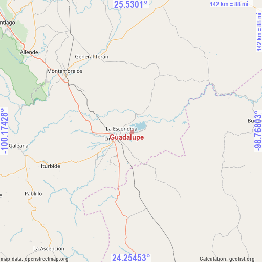
Guadalupe GPS coordinates[2]
24° 53' 38.256" North, 99° 28' 16.14" West
| Map corner | latitude | longitude |
|---|---|---|
| Upper-left | 25.5301°, | -100.17428° |
| Center: | 24.89396°, | -99.47115° |
| Lower-right: | 24.25453°, | -98.76803° |
| Map W x H: | 141.8×141.8 km | = 88.1×88.1mi |
| max Lat: | 32.7° ⇑8.4% North |
| Guadalupe: | 24.89396° |
| min Lat: | ⇓91.6% South 14.53588° |
| min Long | Guadalupe | max Long |
| -117.105° | -99.47115° | -86.73105° |
| W 43.4%⇐ | ⇒56.6% E |
Elevation
Elevation of Guadalupe is 300 m = 984 ft, and this is 953.7 m = 3129 ft below average elevation for this country.
| Max E: |
3497 m = 11473 ft | 72.8% |
| Avg. | 1253.7 m = 4113 ft | |
| Guadalupe | 300 m = 984 ft | |
Min E: |
-1 m = -3 ft | 27.2% |
See also: Mexico elevation on elevation.city.
Geographical zone
Guadalupe is located in North temperate zone (between Tropic of Cancer and the Arctic Circle). Distance of this Northern Tropic circle is 162 km =100.7 mi to South.| Distance of | km | miles | from Guadalupe |
|---|---|---|---|
| North Pole | 7239.1 | 4498.2 | to North |
| Arctic Circle | 4633.2 | 2878.9 | to North |
| Tropic Cancer | 162 | 100.7 | to South |
| Equator | 2767.9 | 1719.9 | to South |


Nearby cities:
15 places around Guadalupe: (largest is in red/bold)
• Ciudad General Terán
45.8 km =28.5 mi,  332°
332°
• Congregación Calles
59.5 km =37 mi,  308°
308°
• El Saucillo
53.8 km =33.4 mi,  143°
143°
• Galeana
61.5 km =38.2 mi,  262°
262°
• Garza Valdez
42.6 km =26.5 mi,  168°
168°
• General Lucio Blanco
19.2 km =11.9 mi,  158°
158°
• Hualahuises
20.6 km =12.8 mi,  266°
266°
• Iturbide
47.5 km =29.5 mi,  246°
246°
• La Escondida
5 km =3.1 mi,  288°
288°
• Linares
10.5 km =6.5 mi, 247°
• Mazatlan
48.7 km =30.3 mi, 312°
• Rayones
62.3 km =38.7 mi,  282°
282°
• Río Verde
7.3 km =4.5 mi, 275°
• Villa Mainero
39.9 km =24.8 mi,  201°
201°
• Villagrán
46.9 km =29.1 mi,  182°
182°
Sources, notices
• [Note1] Compared only with cities in Mexico existing in our database
• [Src1] Map data: © OpenStreetMap contributors (CC-BY-SA)
• [Src2] Other city data from geonames.org with taken over terms of usage.
• [Src3] Geographical zone / Annual Mean Temperature by Robert A. Rohde @ Wikipedia
