Linares geodata
Linares (Nuevo León) is a populated place; located in Mexico in America/Monterrey (GMT-6) time zone. With population of 63,104 people, there are 187 cities with bigger population in this country. Compared to other cities in Mexico, 91.6% of cities are located further ↓South; 57.9% of cities are located further →East and 71.3% of cities have higher elevation than Linares. Note1


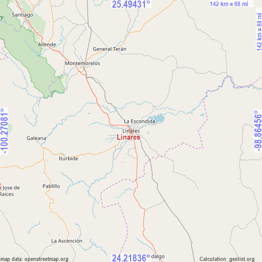
Linares GPS coordinates[2]
24° 51' 28.728" North, 99° 34' 3.648" West
| Map corner | latitude | longitude |
|---|---|---|
| Upper-left | 25.49431°, | -100.27081° |
| Center: | 24.85798°, | -99.56768° |
| Lower-right: | 24.21836°, | -98.86456° |
| Map W x H: | 141.9×141.9 km | = 88.2×88.2mi |
| max Lat: | 32.7° ⇑8.4% North |
| Linares: | 24.85798° |
| min Lat: | ⇓91.6% South 14.53588° |
| min Long | Linares | max Long |
| -117.105° | -99.56768° | -86.73105° |
| W 42.1%⇐ | ⇒57.9% E |
Elevation
Elevation of Linares is 357 m = 1171 ft, and this is 896.7 m = 2942 ft below average elevation for this country.
| Max E: |
3497 m = 11473 ft | 71.3% |
| Avg. | 1253.7 m = 4113 ft | |
| Linares | 357 m = 1171 ft | |
Min E: |
-1 m = -3 ft | 28.7% |
See also: Linares elevation on elevation.city.
Geographical zone
Linares is located in North temperate zone (between Tropic of Cancer and the Arctic Circle). Distance of this Northern Tropic circle is 158 km =98.2 mi to South.| Distance of | km | miles | from Linares |
|---|---|---|---|
| North Pole | 7243.1 | 4500.7 | to North |
| Arctic Circle | 4637.2 | 2881.4 | to North |
| Tropic Cancer | 158 | 98.2 | to South |
| Equator | 2763.9 | 1717.4 | to South |


Nearby cities:
15 places around Linares: (largest is in red/bold)
• Ciudad General Terán
46 km =28.6 mi,  345°
345°
• Congregación Calles
55.1 km =34.2 mi,  317°
317°
• Galeana
51.4 km =31.9 mi,  265°
265°
• Garza Valdez
41.9 km =26 mi,  154°
154°
• General Lucio Blanco
21.7 km =13.5 mi,  129°
129°
• Guadalupe
10.5 km =6.5 mi,  67°
67°
• Hualahuises
11.2 km =7 mi,  284°
284°
• Iturbide
37 km =23 mi,  246°
246°
• La Escondida
7.5 km =4.7 mi,  41°
41°
• Mazatlan
45.2 km =28.1 mi, 324°
• Pablillo
52.4 km =32.6 mi,  235°
235°
• Rayones
54 km =33.6 mi,  289°
289°
• Río Verde
5.4 km =3.4 mi,  27°
27°
• Villa Mainero
33.5 km =20.8 mi,  188°
188°
• Villagrán
43.5 km =27 mi,  169°
169°
Sources, notices
• [Note1] Compared only with cities in Mexico existing in our database
• [Src1] Map data: © OpenStreetMap contributors (CC-BY-SA)
• [Src2] Other city data from geonames.org with taken over terms of usage.
• [Src3] Geographical zone / Annual Mean Temperature by Robert A. Rohde @ Wikipedia
