Coacoyulillo geodata
Coacoyulillo (Guerrero) is a populated place; located in Mexico in America/Mexico_City (GMT-6) time zone. With population of 1,771 people, there are 4902 cities with bigger population in this country. Compared to other cities in Mexico, 84.9% of cities are located further ↑North; 59.4% of cities are located further →East and 69% of cities have higher elevation than Coacoyulillo. Note1


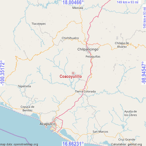
Coacoyulillo GPS coordinates[2]
17° 20' 4.956" North, 99° 38' 54.924" West
| Map corner | latitude | longitude |
|---|---|---|
| Upper-left | 18.00466°, | -100.35172° |
| Center: | 17.33471°, | -99.64859° |
| Lower-right: | 16.66231°, | -98.94547° |
| Map W x H: | 149.3×149.3 km | = 92.8×92.8mi |
| max Lat: | 32.7° ⇑84.9% North |
| Coacoyulillo: | 17.33471° |
| min Lat: | ⇓15.1% South 14.53588° |
| min Long | Coacoyulillo | max Long |
| -117.105° | -99.64859° | -86.73105° |
| W 40.6%⇐ | ⇒59.4% E |
Elevation
Elevation of Coacoyulillo is 469 m = 1539 ft, and this is 784.7 m = 2574 ft below average elevation for this country.
| Max E: |
3497 m = 11473 ft | 69% |
| Avg. | 1253.7 m = 4113 ft | |
| Coacoyulillo | 469 m = 1539 ft | |
Min E: |
-1 m = -3 ft | 31% |
See also: Mexico elevation on elevation.city.
Geographical zone
Coacoyulillo is located in North Torrid zone (between Equator and Tropic of Cancer). Distance of this Northern Tropic circle is 678.5 km =421.6 mi to North.| Distance of | km | miles | from Coacoyulillo |
|---|---|---|---|
| North Pole | 8079.6 | 5020.4 | to North |
| Arctic Circle | 5473.7 | 3401.2 | to North |
| Tropic Cancer | 678.5 | 421.6 | to North |
| Equator | 1927.4 | 1197.6 | to South |


Nearby cities:
15 places around Coacoyulillo: (largest is in red/bold)
• Acahuizotla
19.4 km =12.1 mi,  81°
81°
• Buena Vista de la Salud
17.6 km =10.9 mi,  117°
117°
• Cajelitos
18.1 km =11.2 mi,  114°
114°
• El Fresno
12.6 km =7.8 mi,  31°
31°
• El Ocotito
17.3 km =10.7 mi, 124°
• Garrapatas (Garrapata)
21.3 km =13.2 mi,  139°
139°
• Inscuinatoyac (El Pueblito)
9.4 km =5.8 mi,  293°
293°
• Julián Blanco (Dos Caminos)
18.4 km =11.4 mi,  134°
134°
• La Esperanza
7.4 km =4.6 mi,  35°
35°
• Mohoneras
17.9 km =11.1 mi, 128°
• Palo Blanco
20.8 km =12.9 mi,  68°
68°
• San Vicente
20.3 km =12.6 mi,  349°
349°
• Tlahuizapa
6.1 km =3.8 mi, 125°
• Xolapa
19.7 km =12.2 mi,  169°
169°
• Zoyatepec
9.8 km =6.1 mi,  93°
93°
Sources, notices
• [Note1] Compared only with cities in Mexico existing in our database
• [Src1] Map data: © OpenStreetMap contributors (CC-BY-SA)
• [Src2] Other city data from geonames.org with taken over terms of usage.
• [Src3] Geographical zone / Annual Mean Temperature by Robert A. Rohde @ Wikipedia
