El Fresno geodata
El Fresno (Guerrero) is a populated place; located in Mexico in America/Mexico_City (GMT-6) time zone. With population of 1,107 people, there are 7851 cities with bigger population in this country. Compared to other cities in Mexico, 83.8% of cities are located further ↑North; 58.3% of cities are located further →East and 71.5% of cities have lower elevation than El Fresno. Note1


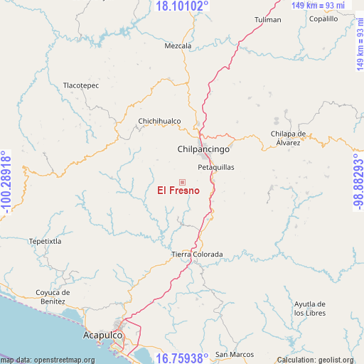
El Fresno GPS coordinates[2]
17° 25' 53.148" North, 99° 35' 9.78" West
| Map corner | latitude | longitude |
|---|---|---|
| Upper-left | 18.10102°, | -100.28918° |
| Center: | 17.43143°, | -99.58605° |
| Lower-right: | 16.75938°, | -98.88293° |
| Map W x H: | 149.2×149.2 km | = 92.7×92.7mi |
| max Lat: | 32.7° ⇑83.8% North |
| El Fresno: | 17.43143° |
| min Lat: | ⇓16.2% South 14.53588° |
| min Long | El Fresno | max Long |
| -117.105° | -99.58605° | -86.73105° |
| W 41.7%⇐ | ⇒58.3% E |
Elevation
Elevation of El Fresno is 1957 m = 6421 ft, and this is 703.3 m = 2307 ft above average elevation for this country.
| Max E: |
3497 m = 11473 ft | 28.5% |
| El Fresno | 1957 m 6421 ft | |
| Avg. | 1253.7 m = 4113 ft | |
Min E: |
-1 m = -3 ft | 71.5% |
See also: Mexico elevation on elevation.city.
Geographical zone
El Fresno is located in North Torrid zone (between Equator and Tropic of Cancer). Distance of this Northern Tropic circle is 667.7 km =414.9 mi to North.| Distance of | km | miles | from El Fresno |
|---|---|---|---|
| North Pole | 8068.9 | 5013.8 | to North |
| Arctic Circle | 5463 | 3394.5 | to North |
| Tropic Cancer | 667.7 | 414.9 | to North |
| Equator | 1938.2 | 1204.3 | to South |


Nearby cities:
15 places around El Fresno: (largest is in red/bold)
• Acahuizotla
14.8 km =9.2 mi,  122°
122°
• Amojileca
15.4 km =9.6 mi,  6°
6°
• Buena Vista de la Salud
21 km =13 mi,  154°
154°
• Cajelitos
20.7 km =12.9 mi, 151°
• Chilpancingo
15.7 km =9.8 mi,  32°
32°
• Coacoyulillo
12.6 km =7.8 mi,  211°
211°
• Inscuinatoyac (El Pueblito)
16.8 km =10.4 mi,  245°
245°
• La Esperanza
5.3 km =3.3 mi, 206°
• Mazatlán
12.9 km =8 mi,  87°
87°
• Palo Blanco
13.1 km =8.1 mi,  103°
103°
• Petaquillas
15.1 km =9.4 mi,  66°
66°
• San Vicente
13.9 km =8.6 mi,  311°
311°
• Tepechicotlán
19 km =11.8 mi, 72°
• Tlahuizapa
14.4 km =8.9 mi,  186°
186°
• Zoyatepec
11.7 km =7.3 mi,  164°
164°
Sources, notices
• [Note1] Compared only with cities in Mexico existing in our database
• [Src1] Map data: © OpenStreetMap contributors (CC-BY-SA)
• [Src2] Other city data from geonames.org with taken over terms of usage.
• [Src3] Geographical zone / Annual Mean Temperature by Robert A. Rohde @ Wikipedia
