La Esperanza geodata
La Esperanza (Guerrero) is a populated place; located in Mexico in America/Mexico_City (GMT-6) time zone. With population of 617 people, there are 13976 cities with bigger population in this country. Compared to other cities in Mexico, 84.3% of cities are located further ↑North; 58.7% of cities are located further →East and 60% of cities have higher elevation than La Esperanza. Note1


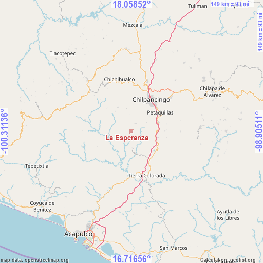
La Esperanza GPS coordinates[2]
17° 23' 19.572" North, 99° 36' 29.628" West
| Map corner | latitude | longitude |
|---|---|---|
| Upper-left | 18.05852°, | -100.31136° |
| Center: | 17.38877°, | -99.60823° |
| Lower-right: | 16.71656°, | -98.90511° |
| Map W x H: | 149.2×149.2 km | = 92.7×92.7mi |
| max Lat: | 32.7° ⇑84.3% North |
| La Esperanza: | 17.38877° |
| min Lat: | ⇓15.7% South 14.53588° |
| min Long | La Esperanza | max Long |
| -117.105° | -99.60823° | -86.73105° |
| W 41.3%⇐ | ⇒58.7% E |
Elevation
Elevation of La Esperanza is 1001 m = 3284 ft, and this is 252.7 m = 829 ft below average elevation for this country.
| Max E: |
3497 m = 11473 ft | 60% |
| Avg. | 1253.7 m = 4113 ft | |
| La Esperanza | 1001 m = 3284 ft | |
Min E: |
-1 m = -3 ft | 40% |
See also: Mexico elevation on elevation.city.
Geographical zone
La Esperanza is located in North Torrid zone (between Equator and Tropic of Cancer). Distance of this Northern Tropic circle is 672.5 km =417.9 mi to North.| Distance of | km | miles | from La Esperanza |
|---|---|---|---|
| North Pole | 8073.6 | 5016.7 | to North |
| Arctic Circle | 5467.7 | 3397.5 | to North |
| Tropic Cancer | 672.5 | 417.9 | to North |
| Equator | 1933.4 | 1201.4 | to South |


Nearby cities:
15 places around La Esperanza: (largest is in red/bold)
• Acahuizotla
15.3 km =9.5 mi,  101°
101°
• Amojileca
20.5 km =12.7 mi,  11°
11°
• Buena Vista de la Salud
18.2 km =11.3 mi,  141°
141°
• Cajelitos
18.2 km =11.3 mi, 137°
• Coacoyulillo
7.4 km =4.6 mi,  215°
215°
• El Fresno
5.3 km =3.3 mi,  26°
26°
• El Ocotito
18.7 km =11.6 mi,  148°
148°
• Inscuinatoyac (El Pueblito)
13.1 km =8.1 mi,  259°
259°
• Mazatlán
16.1 km =10 mi,  70°
70°
• Mohoneras
19.7 km =12.2 mi, 150°
• Palo Blanco
15.2 km =9.4 mi,  83°
83°
• Petaquillas
19.4 km =12.1 mi,  56°
56°
• San Vicente
16.1 km =10 mi,  330°
330°
• Tlahuizapa
9.5 km =5.9 mi,  175°
175°
• Zoyatepec
8.6 km =5.3 mi, 139°
Sources, notices
• [Note1] Compared only with cities in Mexico existing in our database
• [Src1] Map data: © OpenStreetMap contributors (CC-BY-SA)
• [Src2] Other city data from geonames.org with taken over terms of usage.
• [Src3] Geographical zone / Annual Mean Temperature by Robert A. Rohde @ Wikipedia
