Iturbide geodata
Iturbide (Campeche) is a populated place; located in Mexico in America/Merida (GMT-6) time zone. With population of 3,198 people, there are 2828 cities with bigger population in this country. Compared to other cities in Mexico, 52.4% of cities are located further ↑North; 98% of cities are located further ←West and 78.4% of cities have higher elevation than Iturbide. Note1


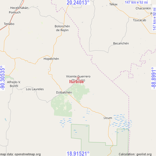
Iturbide GPS coordinates[2]
19° 34' 44.508" North, 89° 36' 7.992" West
| Map corner | latitude | longitude |
|---|---|---|
| Upper-left | 20.24013°, | -90.30535° |
| Center: | 19.57903°, | -89.60222° |
| Lower-right: | 18.91521°, | -88.8991° |
| Map W x H: | 147.3×147.3 km | = 91.5×91.5mi |
| max Lat: | 32.7° ⇑52.4% North |
| Iturbide: | 19.57903° |
| min Lat: | ⇓47.6% South 14.53588° |
| min Long | Iturbide | max Long |
| -117.105° | -89.60222° | -86.73105° |
| W 98%⇐ | ⇒2% E |
Elevation
Elevation of Iturbide is 123 m = 404 ft, and this is 1130.7 m = 3710 ft below average elevation for this country.
| Max E: |
3497 m = 11473 ft | 78.4% |
| Avg. | 1253.7 m = 4113 ft | |
| Iturbide | 123 m = 404 ft | |
Min E: |
-1 m = -3 ft | 21.6% |
See also: Mexico elevation on elevation.city.
Geographical zone
Iturbide is located in North Torrid zone (between Equator and Tropic of Cancer). Distance of this Northern Tropic circle is 428.9 km =266.5 mi to North.| Distance of | km | miles | from Iturbide |
|---|---|---|---|
| North Pole | 7830.1 | 4865.4 | to North |
| Arctic Circle | 5224.2 | 3246.2 | to North |
| Tropic Cancer | 428.9 | 266.5 | to North |
| Equator | 2177 | 1352.7 | to South |


Nearby cities:
15 places around Iturbide: (largest is in red/bold)
• Becanchén
52 km =32.3 mi,  50°
50°
• Bolonchén de Rejón
49.6 km =30.8 mi,  342°
342°
• Cancabchén
30.5 km =19 mi,  186°
186°
• Chunchintok
24.3 km =15.1 mi,  175°
175°
• Crucero San Luis
42.8 km =26.6 mi,  288°
288°
• Dzibalchén
19 km =11.8 mi,  225°
225°
• Hopelchén
31.5 km =19.6 mi,  306°
306°
• Ich-Ek
41.8 km =26 mi, 294°
• Konchén
26.2 km =16.3 mi,  273°
273°
• Los Laureles
42.3 km =26.3 mi,  256°
256°
• Santa Rita
29.3 km =18.2 mi, 285°
• Suc-Tuc
48 km =29.8 mi, 288°
• Ukúm
46.8 km =29.1 mi,  143°
143°
• Xcupil
28.6 km =17.8 mi, 289°
• Xmabén
48.7 km =30.3 mi, 141°
Sources, notices
• [Note1] Compared only with cities in Mexico existing in our database
• [Src1] Map data: © OpenStreetMap contributors (CC-BY-SA)
• [Src2] Other city data from geonames.org with taken over terms of usage.
• [Src3] Geographical zone / Annual Mean Temperature by Robert A. Rohde @ Wikipedia
