Yutecoso Cuauhtémoc geodata
Yutecoso Cuauhtémoc (Oaxaca) is a populated place; located in Mexico in America/Mexico_City (GMT-6) time zone. With population of 631 people, there are 13723 cities with bigger population in this country. Compared to other cities in Mexico, 90% of cities are located further ↑North; 67.2% of cities are located further ←West and 76.4% of cities have lower elevation than Yutecoso Cuauhtémoc. Note1


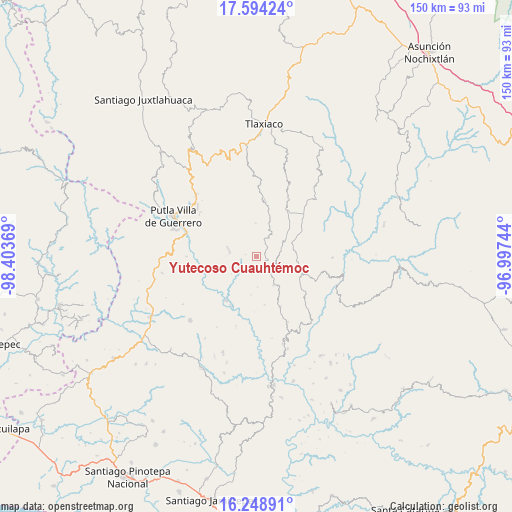
Yutecoso Cuauhtémoc GPS coordinates[2]
16° 55' 22.008" North, 97° 42' 2.016" West
| Map corner | latitude | longitude |
|---|---|---|
| Upper-left | 17.59424°, | -98.40369° |
| Center: | 16.92278°, | -97.70056° |
| Lower-right: | 16.24891°, | -96.99744° |
| Map W x H: | 149.6×149.6 km | = 93×93mi |
| max Lat: | 32.7° ⇑90% North |
| Yutecoso Cuauhtémoc: | 16.92278° |
| min Lat: | ⇓10% South 14.53588° |
| min Long | Yutecoso Cuauht | max Long |
| -117.105° | -97.70056° | -86.73105° |
| W 67.2%⇐ | ⇒32.8% E |
Elevation
Elevation of Yutecoso Cuauhtémoc is 2055 m = 6742 ft, and this is 801.3 m = 2629 ft above average elevation for this country.
| Max E: |
3497 m = 11473 ft | 23.6% |
| Yutecoso Cuauhtémoc | 2055 m 6742 ft | |
| Avg. | 1253.7 m = 4113 ft | |
Min E: |
-1 m = -3 ft | 76.4% |
See also: Mexico elevation on elevation.city.
Geographical zone
Yutecoso Cuauhtémoc is located in North Torrid zone (between Equator and Tropic of Cancer). Distance of this Northern Tropic circle is 724.3 km =450.1 mi to North.| Distance of | km | miles | from Yutecoso Cuauhtémoc |
|---|---|---|---|
| North Pole | 8125.4 | 5048.9 | to North |
| Arctic Circle | 5519.5 | 3429.7 | to North |
| Tropic Cancer | 724.3 | 450.1 | to North |
| Equator | 1881.6 | 1169.2 | to South |


Nearby cities:
15 places around Yutecoso Cuauhtémoc: (largest is in red/bold)
• Agua del Toro
7.9 km =4.9 mi,  347°
347°
• Aldama
12.1 km =7.5 mi,  66°
66°
• Asunción Atoyaquillo
15.8 km =9.8 mi,  213°
213°
• Chapultepec
14.9 km =9.3 mi,  62°
62°
• Hidalgo
11.4 km =7.1 mi,  187°
187°
• Imperio
11 km =6.8 mi,  93°
93°
• Miramar
13.6 km =8.5 mi,  309°
309°
• Morelos
14.5 km =9 mi,  169°
169°
• San Sebastián Nopalera
8.5 km =5.3 mi,  285°
285°
• Santa Cruz Itundujia
6.9 km =4.3 mi,  141°
141°
• Santa María Ocotlán
5.5 km =3.4 mi,  324°
324°
• Santa María Yucuhiti
12.9 km =8 mi,  325°
325°
• Santiago Nuyoó
12.4 km =7.7 mi, 325°
• Santiago Yosondúa
14.2 km =8.8 mi,  111°
111°
• Zimatlán
14.1 km =8.8 mi,  277°
277°
Sources, notices
• [Note1] Compared only with cities in Mexico existing in our database
• [Src1] Map data: © OpenStreetMap contributors (CC-BY-SA)
• [Src2] Other city data from geonames.org with taken over terms of usage.
• [Src3] Geographical zone / Annual Mean Temperature by Robert A. Rohde @ Wikipedia
