Zimatlán geodata
Zimatlán (Oaxaca) is a populated place; located in Mexico in America/Mexico_City (GMT-6) time zone. With population of 580 people, there are 14779 cities with bigger population in this country. Compared to other cities in Mexico, 89.7% of cities are located further ↑North; 65.7% of cities are located further ←West and 62.1% of cities have higher elevation than Zimatlán. Note1


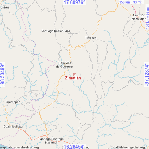
Zimatlán GPS coordinates[2]
16° 56' 18.06" North, 97° 49' 54.696" West
| Map corner | latitude | longitude |
|---|---|---|
| Upper-left | 17.60976°, | -98.53499° |
| Center: | 16.93835°, | -97.83186° |
| Lower-right: | 16.26454°, | -97.12874° |
| Map W x H: | 149.6×149.6 km | = 93×93mi |
| max Lat: | 32.7° ⇑89.7% North |
| Zimatlán: | 16.93835° |
| min Lat: | ⇓10.3% South 14.53588° |
| min Long | Zimatlán | max Long |
| -117.105° | -97.83186° | -86.73105° |
| W 65.7%⇐ | ⇒34.3% E |
Elevation
Elevation of Zimatlán is 880 m = 2887 ft, and this is 373.7 m = 1226 ft below average elevation for this country.
| Max E: |
3497 m = 11473 ft | 62.1% |
| Avg. | 1253.7 m = 4113 ft | |
| Zimatlán | 880 m = 2887 ft | |
Min E: |
-1 m = -3 ft | 37.9% |
See also: Mexico elevation on elevation.city.
Geographical zone
Zimatlán is located in North Torrid zone (between Equator and Tropic of Cancer). Distance of this Northern Tropic circle is 722.6 km =449 mi to North.| Distance of | km | miles | from Zimatlán |
|---|---|---|---|
| North Pole | 8123.7 | 5047.8 | to North |
| Arctic Circle | 5517.8 | 3428.6 | to North |
| Tropic Cancer | 722.6 | 449 | to North |
| Equator | 1883.4 | 1170.3 | to South |


Nearby cities:
15 places around Zimatlán: (largest is in red/bold)
• Agua del Toro
13.7 km =8.5 mi,  63°
63°
• Concepción del Progreso
12.4 km =7.7 mi,  345°
345°
• La Zafra
7.9 km =4.9 mi,  310°
310°
• Malpica
11.6 km =7.2 mi, 314°
• Miramar
7.8 km =4.8 mi,  26°
26°
• Putla Villa de Guerrero
14.2 km =8.8 mi, 313°
• San Juan Lagunas
12.4 km =7.7 mi,  302°
302°
• San Juan Teponaxtla
10.7 km =6.6 mi, 345°
• San Miguel Reyes
6.8 km =4.2 mi,  253°
253°
• San Pedro Siniyuvi
5.2 km =3.2 mi, 349°
• San Sebastián Nopalera
5.8 km =3.6 mi,  84°
84°
• Santa María Ocotlán
11.1 km =6.9 mi, 75°
• Santa María Yucuhiti
11.1 km =6.9 mi,  36°
36°
• Santiago Nuyoó
10.9 km =6.8 mi, 39°
• Yutecoso Cuauhtémoc
14.1 km =8.8 mi,  97°
97°
Sources, notices
• [Note1] Compared only with cities in Mexico existing in our database
• [Src1] Map data: © OpenStreetMap contributors (CC-BY-SA)
• [Src2] Other city data from geonames.org with taken over terms of usage.
• [Src3] Geographical zone / Annual Mean Temperature by Robert A. Rohde @ Wikipedia
