China geodata
China (Nuevo León) is a seat of a second-order administrative division; located in Mexico in America/Monterrey (GMT-6) time zone. With population of 8,997 people, there are 1054 cities with bigger population in this country. Compared to other cities in Mexico, 93.7% of cities are located further ↓South; 53.4% of cities are located further →East and 77.6% of cities have higher elevation than China. Note1


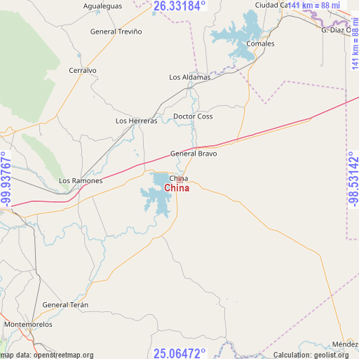
China GPS coordinates[2]
25° 41' 59.892" North, 99° 14' 4.344" West
| Map corner | latitude | longitude |
|---|---|---|
| Upper-left | 26.33184°, | -99.93767° |
| Center: | 25.69997°, | -99.23454° |
| Lower-right: | 25.06472°, | -98.53142° |
| Map W x H: | 140.9×140.9 km | = 87.6×87.6mi |
| max Lat: | 32.7° ⇑6.3% North |
| China: | 25.69997° |
| min Lat: | ⇓93.7% South 14.53588° |
| min Long | China | max Long |
| -117.105° | -99.23454° | -86.73105° |
| W 46.6%⇐ | ⇒53.4% E |
Elevation
Elevation of China is 140 m = 459 ft, and this is 1113.7 m = 3654 ft below average elevation for this country.
| Max E: |
3497 m = 11473 ft | 77.6% |
| Avg. | 1253.7 m = 4113 ft | |
| China | 140 m = 459 ft | |
Min E: |
-1 m = -3 ft | 22.4% |
See also: Mexico elevation on elevation.city.
Geographical zone
China is located in North temperate zone (between Tropic of Cancer and the Arctic Circle). Distance of this Northern Tropic circle is 251.6 km =156.3 mi to South.| Distance of | km | miles | from China |
|---|---|---|---|
| North Pole | 7149.5 | 4442.5 | to North |
| Arctic Circle | 4543.6 | 2823.3 | to North |
| Tropic Cancer | 251.6 | 156.3 | to South |
| Equator | 2857.6 | 1775.6 | to South |


Nearby cities:
15 places around China: (largest is in red/bold)
• Ciudad Cerralvo
57.3 km =35.6 mi,  318°
318°
• Ciudad General Terán
66.6 km =41.4 mi,  222°
222°
• Comales
62.1 km =38.6 mi,  30°
30°
• Doctor Coss
25.5 km =15.8 mi,  11°
11°
• General Bravo
11.6 km =7.2 mi, 27°
• General Tapia (Mariano Escobedo)
24 km =14.9 mi,  54°
54°
• General Treviño
63.3 km =39.3 mi,  336°
336°
• Los Aldamas
40.5 km =25.2 mi, 5°
• Los Herreras
28.7 km =17.8 mi, 323°
• Los Ramones
39.2 km =24.4 mi,  269°
269°
• Melchor Ocampo
50.2 km =31.2 mi, 321°
• Pueblo Nuevo
57.9 km =36 mi,  245°
245°
• San Isidro
52.4 km =32.6 mi, 266°
• San Juan
63.3 km =39.3 mi, 253°
• Santa Isabel y Dolores
57.3 km =35.6 mi, 251°
Sources, notices
• [Note1] Compared only with cities in Mexico existing in our database
• [Src1] Map data: © OpenStreetMap contributors (CC-BY-SA)
• [Src2] Other city data from geonames.org with taken over terms of usage.
• [Src3] Geographical zone / Annual Mean Temperature by Robert A. Rohde @ Wikipedia
