La Defensa geodata
La Defensa (Veracruz) is a populated place; located in Mexico in America/Mexico_City (GMT-6) time zone. With population of 983 people, there are 8847 cities with bigger population in this country. Compared to other cities in Mexico, 71.2% of cities are located further ↓South; 67% of cities are located further ←West and 76.2% of cities have higher elevation than La Defensa. Note1


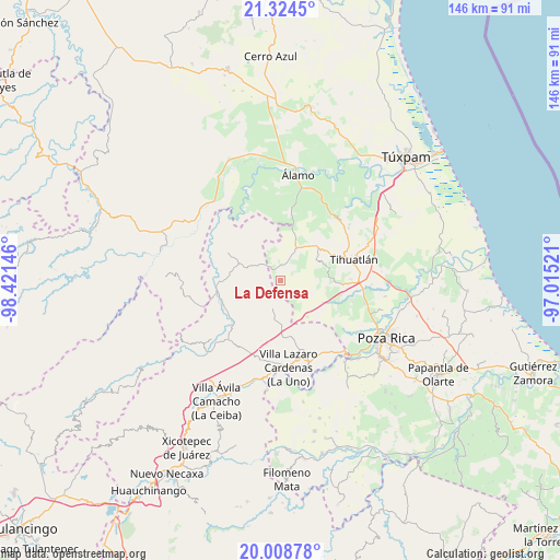
La Defensa GPS coordinates[2]
20° 40' 5.016" North, 97° 43' 5.988" West
| Map corner | latitude | longitude |
|---|---|---|
| Upper-left | 21.3245°, | -98.42146° |
| Center: | 20.66806°, | -97.71833° |
| Lower-right: | 20.00878°, | -97.01521° |
| Map W x H: | 146.3×146.3 km | = 90.9×90.9mi |
| max Lat: | 32.7° ⇑28.8% North |
| La Defensa: | 20.66806° |
| min Lat: | ⇓71.2% South 14.53588° |
| min Long | La Defensa | max Long |
| -117.105° | -97.71833° | -86.73105° |
| W 67%⇐ | ⇒33% E |
Elevation
Elevation of La Defensa is 179 m = 587 ft, and this is 1074.7 m = 3526 ft below average elevation for this country.
| Max E: |
3497 m = 11473 ft | 76.2% |
| Avg. | 1253.7 m = 4113 ft | |
| La Defensa | 179 m = 587 ft | |
Min E: |
-1 m = -3 ft | 23.8% |
See also: Mexico elevation on elevation.city.
Geographical zone
La Defensa is located in North Torrid zone (between Equator and Tropic of Cancer). Distance of this Northern Tropic circle is 307.8 km =191.3 mi to North.| Distance of | km | miles | from La Defensa |
|---|---|---|---|
| North Pole | 7709 | 4790.1 | to North |
| Arctic Circle | 5103.1 | 3170.9 | to North |
| Tropic Cancer | 307.8 | 191.3 | to North |
| Equator | 2298.1 | 1428 | to South |


Nearby cities:
15 places around La Defensa: (largest is in red/bold)
• Castillo de Teayo
12.9 km =8 mi,  45°
45°
• El Tecomate
12.7 km =7.9 mi,  333°
333°
• Huitzilac
7.3 km =4.5 mi,  199°
199°
• Jaltocan
11.7 km =7.3 mi,  242°
242°
• Jiliapa Segundo
12.4 km =7.7 mi,  80°
80°
• La Guadalupe
8.9 km =5.5 mi,  67°
67°
• La Pahua
15.4 km =9.6 mi,  246°
246°
• Las Balsas
7.9 km =4.9 mi,  299°
299°
• Mequetla
14.4 km =8.9 mi,  12°
12°
• Metlaltoyuca
15.8 km =9.8 mi, 298°
• Moctezuma
10.6 km =6.6 mi,  292°
292°
• Palma Real de Adentro
14.4 km =8.9 mi,  355°
355°
• Poza Azul de los Reyes
6.3 km =3.9 mi,  148°
148°
• San José
11.7 km =7.3 mi,  171°
171°
• Teayo
9.4 km =5.8 mi,  25°
25°
Sources, notices
• [Note1] Compared only with cities in Mexico existing in our database
• [Src1] Map data: © OpenStreetMap contributors (CC-BY-SA)
• [Src2] Other city data from geonames.org with taken over terms of usage.
• [Src3] Geographical zone / Annual Mean Temperature by Robert A. Rohde @ Wikipedia
