Teayo geodata
Teayo (Veracruz) is a populated place; located in Mexico in America/Mexico_City (GMT-6) time zone. With population of 1,349 people, there are 6447 cities with bigger population in this country. Compared to other cities in Mexico, 72.4% of cities are located further ↓South; 67.5% of cities are located further ←West and 80.1% of cities have higher elevation than Teayo. Note1


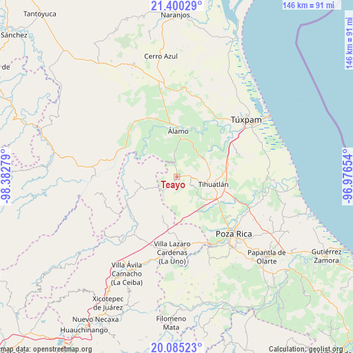
Teayo GPS coordinates[2]
20° 44' 39.084" North, 97° 40' 46.776" West
| Map corner | latitude | longitude |
|---|---|---|
| Upper-left | 21.40029°, | -98.38279° |
| Center: | 20.74419°, | -97.67966° |
| Lower-right: | 20.08523°, | -96.97654° |
| Map W x H: | 146.2×146.2 km | = 90.8×90.8mi |
| max Lat: | 32.7° ⇑27.6% North |
| Teayo: | 20.74419° |
| min Lat: | ⇓72.4% South 14.53588° |
| min Long | Teayo | max Long |
| -117.105° | -97.67966° | -86.73105° |
| W 67.5%⇐ | ⇒32.5% E |
Elevation
Elevation of Teayo is 93 m = 305 ft, and this is 1160.7 m = 3808 ft below average elevation for this country.
| Max E: |
3497 m = 11473 ft | 80.1% |
| Avg. | 1253.7 m = 4113 ft | |
| Teayo | 93 m = 305 ft | |
Min E: |
-1 m = -3 ft | 19.9% |
See also: Mexico elevation on elevation.city.
Geographical zone
Teayo is located in North Torrid zone (between Equator and Tropic of Cancer). Distance of this Northern Tropic circle is 299.4 km =186 mi to North.| Distance of | km | miles | from Teayo |
|---|---|---|---|
| North Pole | 7700.5 | 4784.9 | to North |
| Arctic Circle | 5094.6 | 3165.6 | to North |
| Tropic Cancer | 299.4 | 186 | to North |
| Equator | 2306.5 | 1433.2 | to South |


Nearby cities:
15 places around Teayo: (largest is in red/bold)
• Aquiles Serdán
10.7 km =6.6 mi,  356°
356°
• Castillo de Teayo
5.2 km =3.2 mi,  83°
83°
• Cerro Dulce
13.2 km =8.2 mi,  31°
31°
• El Bejucal
7.1 km =4.4 mi,  18°
18°
• El Tecomate
10.1 km =6.3 mi,  287°
287°
• Jiliapa Segundo
10.4 km =6.5 mi,  127°
127°
• La Defensa
9.4 km =5.8 mi,  205°
205°
• La Guadalupe
6.6 km =4.1 mi,  140°
140°
• La Providencia
11 km =6.8 mi,  352°
352°
• Las Balsas
11.8 km =7.3 mi,  247°
247°
• Lima Vieja
7 km =4.3 mi,  45°
45°
• Mequetla
5.7 km =3.5 mi, 350°
• Palma Real de Adentro
7.9 km =4.9 mi,  319°
319°
• Tincontlán
8.7 km =5.4 mi, 352°
• Venustiano Carranza
10.4 km =6.5 mi,  331°
331°
Sources, notices
• [Note1] Compared only with cities in Mexico existing in our database
• [Src1] Map data: © OpenStreetMap contributors (CC-BY-SA)
• [Src2] Other city data from geonames.org with taken over terms of usage.
• [Src3] Geographical zone / Annual Mean Temperature by Robert A. Rohde @ Wikipedia
