Las Balsas geodata
Las Balsas (Puebla) is a populated place; located in Mexico in America/Mexico_City (GMT-6) time zone. With population of 505 people, there are 16660 cities with bigger population in this country. Compared to other cities in Mexico, 71.7% of cities are located further ↓South; 66.3% of cities are located further ←West and 74.9% of cities have higher elevation than Las Balsas. Note1


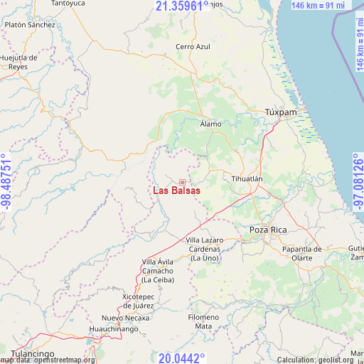
Las Balsas GPS coordinates[2]
20° 42' 11.988" North, 97° 47' 3.768" West
| Map corner | latitude | longitude |
|---|---|---|
| Upper-left | 21.35961°, | -98.48751° |
| Center: | 20.70333°, | -97.78438° |
| Lower-right: | 20.0442°, | -97.08126° |
| Map W x H: | 146.3×146.3 km | = 90.9×90.9mi |
| max Lat: | 32.7° ⇑28.3% North |
| Las Balsas: | 20.70333° |
| min Lat: | ⇓71.7% South 14.53588° |
| min Long | Las Balsas | max Long |
| -117.105° | -97.78438° | -86.73105° |
| W 66.3%⇐ | ⇒33.7% E |
Elevation
Elevation of Las Balsas is 226 m = 741 ft, and this is 1027.7 m = 3372 ft below average elevation for this country.
| Max E: |
3497 m = 11473 ft | 74.9% |
| Avg. | 1253.7 m = 4113 ft | |
| Las Balsas | 226 m = 741 ft | |
Min E: |
-1 m = -3 ft | 25.1% |
See also: Mexico elevation on elevation.city.
Geographical zone
Las Balsas is located in North Torrid zone (between Equator and Tropic of Cancer). Distance of this Northern Tropic circle is 303.9 km =188.8 mi to North.| Distance of | km | miles | from Las Balsas |
|---|---|---|---|
| North Pole | 7705.1 | 4787.7 | to North |
| Arctic Circle | 5099.2 | 3168.5 | to North |
| Tropic Cancer | 303.9 | 188.8 | to North |
| Equator | 2302 | 1430.4 | to South |


Nearby cities:
15 places around Las Balsas: (largest is in red/bold)
• Agua Linda
15.6 km =9.7 mi,  213°
213°
• El Tecomate
7.6 km =4.7 mi,  9°
9°
• Huitzilac
11.6 km =7.2 mi,  157°
157°
• Jaltocan
9.9 km =6.2 mi,  200°
200°
• La Defensa
7.9 km =4.9 mi,  119°
119°
• La Guadalupe
15.1 km =9.4 mi,  92°
92°
• La Pahua
12.5 km =7.8 mi,  215°
215°
• Mequetla
14.2 km =8.8 mi,  44°
44°
• Metlaltoyuca
7.9 km =4.9 mi,  297°
297°
• Moctezuma
2.9 km =1.8 mi,  271°
271°
• Palma Real de Adentro
11.9 km =7.4 mi,  28°
28°
• Poza Azul de los Reyes
13.8 km =8.6 mi,  132°
132°
• Progreso de Allende
14.8 km =9.2 mi,  231°
231°
• Teayo
11.8 km =7.3 mi,  67°
67°
• Venustiano Carranza
14.8 km =9.2 mi,  23°
23°
Sources, notices
• [Note1] Compared only with cities in Mexico existing in our database
• [Src1] Map data: © OpenStreetMap contributors (CC-BY-SA)
• [Src2] Other city data from geonames.org with taken over terms of usage.
• [Src3] Geographical zone / Annual Mean Temperature by Robert A. Rohde @ Wikipedia
