El Cuyo geodata
El Cuyo (Yucatán) is a populated place; located in Mexico in America/Merida (GMT-6) time zone. With population of 1,567 people, there are 5510 cities with bigger population in this country. Compared to other cities in Mexico, 81.5% of cities are located further ↓South; 99.8% of cities are located further ←West and 98.7% of cities have higher elevation than El Cuyo. Note1


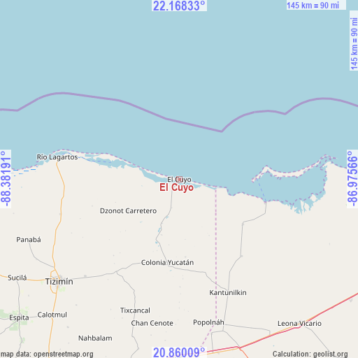
El Cuyo GPS coordinates[2]
21° 30' 56.448" North, 87° 40' 43.608" West
| Map corner | latitude | longitude |
|---|---|---|
| Upper-left | 22.16833°, | -88.38191° |
| Center: | 21.51568°, | -87.67878° |
| Lower-right: | 20.86009°, | -86.97566° |
| Map W x H: | 145.5×145.5 km | = 90.4×90.4mi |
| max Lat: | 32.7° ⇑18.5% North |
| El Cuyo: | 21.51568° |
| min Lat: | ⇓81.5% South 14.53588° |
| min Long | El Cuyo | max Long |
| -117.105° | -87.67878° | -86.73105° |
| W 99.8%⇐ | ⇒0.2% E |
Elevation
Elevation of El Cuyo is 7 m = 23 ft, and this is 1246.7 m = 4090 ft below average elevation for this country.
| Max E: |
3497 m = 11473 ft | 98.7% |
| Avg. | 1253.7 m = 4113 ft | |
| El Cuyo | 7 m = 23 ft | |
Min E: |
-1 m = -3 ft | 1.3% |
See also: Mexico elevation on elevation.city.
Geographical zone
El Cuyo is located in North Torrid zone (between Equator and Tropic of Cancer). Distance of this Northern Tropic circle is 213.6 km =132.7 mi to North.| Distance of | km | miles | from El Cuyo |
|---|---|---|---|
| North Pole | 7614.7 | 4731.6 | to North |
| Arctic Circle | 5008.9 | 3112.4 | to North |
| Tropic Cancer | 213.6 | 132.7 | to North |
| Equator | 2392.3 | 1486.5 | to South |


Nearby cities:
15 places around El Cuyo: (largest is in red/bold)
• Chan Cenote
59.3 km =36.8 mi,  190°
190°
• Chiquilá
36.7 km =22.8 mi,  104°
104°
• Colonia Yucatán
34 km =21.1 mi, 187°
• Dzonot Carretero
24.3 km =15.1 mi,  238°
238°
• Isla Holbox
31.1 km =19.3 mi,  88°
88°
• Kantunilkín
50.1 km =31.1 mi,  156°
156°
• Las Coloradas
33.8 km =21 mi,  287°
287°
• Loché
50.3 km =31.3 mi,  253°
253°
• Popolnah
59.3 km =36.8 mi,  168°
168°
• Río Lagartos
50.3 km =31.3 mi,  280°
280°
• San Angel
40.3 km =25 mi,  140°
140°
• San Felipe
57.6 km =35.8 mi, 275°
• Solferino
31.6 km =19.6 mi,  125°
125°
• Sucopó
54.8 km =34.1 mi,  224°
224°
• Tixcancal
56.2 km =34.9 mi,  198°
198°
Sources, notices
• [Note1] Compared only with cities in Mexico existing in our database
• [Src1] Map data: © OpenStreetMap contributors (CC-BY-SA)
• [Src2] Other city data from geonames.org with taken over terms of usage.
• [Src3] Geographical zone / Annual Mean Temperature by Robert A. Rohde @ Wikipedia
