Río Lagartos geodata
Río Lagartos (Yucatán) is a populated place; located in Mexico in America/Merida (GMT-6) time zone. With population of 2,218 people, there are 3957 cities with bigger population in this country. Compared to other cities in Mexico, 81.9% of cities are located further ↓South; 99.6% of cities are located further ←West and 99.8% of cities have higher elevation than Río Lagartos. Note1


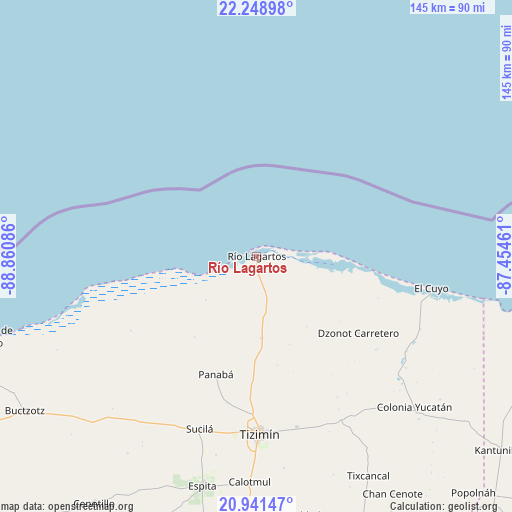
Río Lagartos GPS coordinates[2]
21° 35' 48.12" North, 88° 9' 27.828" West
| Map corner | latitude | longitude |
|---|---|---|
| Upper-left | 22.24898°, | -88.86086° |
| Center: | 21.5967°, | -88.15773° |
| Lower-right: | 20.94147°, | -87.45461° |
| Map W x H: | 145.4×145.4 km | = 90.3×90.3mi |
| max Lat: | 32.7° ⇑18.1% North |
| Río Lagartos: | 21.5967° |
| min Lat: | ⇓81.9% South 14.53588° |
| min Long | Río Lagartos | max Long |
| -117.105° | -88.15773° | -86.73105° |
| W 99.6%⇐ | ⇒0.40000000000001% E |
Elevation
Elevation of Río Lagartos is 3 m = 10 ft, and this is 1250.7 m = 4103 ft below average elevation for this country.
| Max E: |
3497 m = 11473 ft | 99.8% |
| Avg. | 1253.7 m = 4113 ft | |
| Río Lagartos | 3 m = 10 ft | |
Min E: |
-1 m = -3 ft | 0.2% |
See also: Mexico elevation on elevation.city.
Geographical zone
Río Lagartos is located in North Torrid zone (between Equator and Tropic of Cancer). Distance of this Northern Tropic circle is 204.6 km =127.1 mi to North.| Distance of | km | miles | from Río Lagartos |
|---|---|---|---|
| North Pole | 7605.7 | 4726 | to North |
| Arctic Circle | 4999.8 | 3106.7 | to North |
| Tropic Cancer | 204.6 | 127.1 | to North |
| Equator | 2401.3 | 1492.1 | to South |


Nearby cities:
15 places around Río Lagartos: (largest is in red/bold)
• Calotmul
64.1 km =39.8 mi,  181°
181°
• Colonia Yucatán
61.9 km =38.5 mi,  133°
133°
• Dzonot Carretero
36.2 km =22.5 mi, 127°
• El Cuyo
50.3 km =31.3 mi,  100°
100°
• Espita
66.9 km =41.6 mi,  193°
193°
• Holcá
57.3 km =35.6 mi, 191°
• Las Coloradas
17.3 km =10.7 mi,  85°
85°
• Loché
23.2 km =14.4 mi, 176°
• Panabá
35.4 km =22 mi,  199°
199°
• Pocoboch
69.3 km =43.1 mi, 176°
• San Felipe
8.5 km =5.3 mi,  246°
246°
• Sucilá
51.6 km =32.1 mi, 198°
• Sucopó
49.7 km =30.9 mi,  166°
166°
• Tixcancal
70 km =43.5 mi,  152°
152°
• Tizimín
50.5 km =31.4 mi, 179°
Sources, notices
• [Note1] Compared only with cities in Mexico existing in our database
• [Src1] Map data: © OpenStreetMap contributors (CC-BY-SA)
• [Src2] Other city data from geonames.org with taken over terms of usage.
• [Src3] Geographical zone / Annual Mean Temperature by Robert A. Rohde @ Wikipedia
