Solferino geodata
Solferino (Quintana Roo) is a populated place; located in Mexico in America/Cancun (GMT-5) time zone. With population of 799 people, there are 10920 cities with bigger population in this country. Compared to other cities in Mexico, 80.5% of cities are located further ↓South; 99.9% of cities are located further ←West and 94.6% of cities have higher elevation than Solferino. Note1


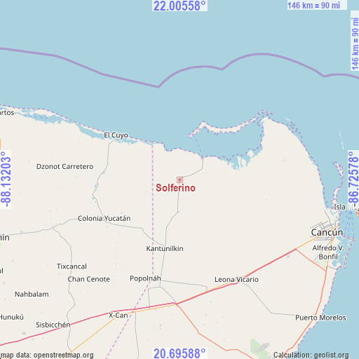
Solferino GPS coordinates[2]
21° 21' 7.884" North, 87° 25' 44.04" West
| Map corner | latitude | longitude |
|---|---|---|
| Upper-left | 22.00558°, | -88.13203° |
| Center: | 21.35219°, | -87.4289° |
| Lower-right: | 20.69588°, | -86.72578° |
| Map W x H: | 145.6×145.6 km | = 90.5×90.5mi |
| max Lat: | 32.7° ⇑19.5% North |
| Solferino: | 21.35219° |
| min Lat: | ⇓80.5% South 14.53588° |
| min Long | Solferino | max Long |
| -117.105° | -87.4289° | -86.73105° |
| W 99.9%⇐ | ⇒0.099999999999994% E |
Elevation
Elevation of Solferino is 14 m = 46 ft, and this is 1239.7 m = 4067 ft below average elevation for this country.
| Max E: |
3497 m = 11473 ft | 94.6% |
| Avg. | 1253.7 m = 4113 ft | |
| Solferino | 14 m = 46 ft | |
Min E: |
-1 m = -3 ft | 5.4% |
See also: Mexico elevation on elevation.city.
Geographical zone
Solferino is located in North Torrid zone (between Equator and Tropic of Cancer). Distance of this Northern Tropic circle is 231.8 km =144 mi to North.| Distance of | km | miles | from Solferino |
|---|---|---|---|
| North Pole | 7632.9 | 4742.9 | to North |
| Arctic Circle | 5027 | 3123.6 | to North |
| Tropic Cancer | 231.8 | 144 | to North |
| Equator | 2374.1 | 1475.2 | to South |


Nearby cities:
15 places around Solferino: (largest is in red/bold)
• Chiquilá
13.2 km =8.2 mi,  47°
47°
• Colonia Yucatán
34.3 km =21.3 mi,  243°
243°
• Dzonot Carretero
46.9 km =29.1 mi,  276°
276°
• El Cedral
46.4 km =28.8 mi,  195°
195°
• El Cuyo
31.6 km =19.6 mi,  305°
305°
• El Ideal
53.7 km =33.4 mi,  192°
192°
• El Porvenir
53.8 km =33.4 mi,  124°
124°
• El Tintal
51.3 km =31.9 mi,  184°
184°
• Ignacio Zaragoza
53.3 km =33.1 mi, 190°
• Isla Holbox
19.8 km =12.3 mi,  15°
15°
• Kantunilkín
28.5 km =17.7 mi, 192°
• Leona Vicario
46.7 km =29 mi,  149°
149°
• Popolnah
42.2 km =26.2 mi, 199°
• San Angel
13 km =8.1 mi, 181°
• Vicente Guerrero
41.6 km =25.8 mi, 189°
Sources, notices
• [Note1] Compared only with cities in Mexico existing in our database
• [Src1] Map data: © OpenStreetMap contributors (CC-BY-SA)
• [Src2] Other city data from geonames.org with taken over terms of usage.
• [Src3] Geographical zone / Annual Mean Temperature by Robert A. Rohde @ Wikipedia
