Coyay geodata
Coyay (Puebla) is a populated place; located in Mexico in America/Mexico_City (GMT-6) time zone. With population of 769 people, there are 11375 cities with bigger population in this country. Compared to other cities in Mexico, 58.8% of cities are located further ↓South; 66.6% of cities are located further ←West and 62.9% of cities have higher elevation than Coyay. Note1


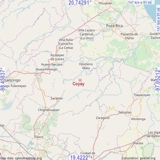
Coyay GPS coordinates[2]
20° 5' 2.22" North, 97° 45' 18.864" West
| Map corner | latitude | longitude |
|---|---|---|
| Upper-left | 20.74291°, | -98.45837° |
| Center: | 20.08395°, | -97.75524° |
| Lower-right: | 19.4222°, | -97.05212° |
| Map W x H: | 146.8×146.9 km | = 91.2×91.3mi |
| max Lat: | 32.7° ⇑41.2% North |
| Coyay: | 20.08395° |
| min Lat: | ⇓58.8% South 14.53588° |
| min Long | Coyay | max Long |
| -117.105° | -97.75524° | -86.73105° |
| W 66.6%⇐ | ⇒33.4% E |
Elevation
Elevation of Coyay is 828 m = 2717 ft, and this is 425.7 m = 1397 ft below average elevation for this country.
| Max E: |
3497 m = 11473 ft | 62.9% |
| Avg. | 1253.7 m = 4113 ft | |
| Coyay | 828 m = 2717 ft | |
Min E: |
-1 m = -3 ft | 37.1% |
See also: Mexico elevation on elevation.city.
Geographical zone
Coyay is located in North Torrid zone (between Equator and Tropic of Cancer). Distance of this Northern Tropic circle is 372.8 km =231.6 mi to North.| Distance of | km | miles | from Coyay |
|---|---|---|---|
| North Pole | 7773.9 | 4830.5 | to North |
| Arctic Circle | 5168 | 3211.2 | to North |
| Tropic Cancer | 372.8 | 231.6 | to North |
| Equator | 2233.1 | 1387.6 | to South |


Nearby cities:
15 places around Coyay: (largest is in red/bold)
• Altica
4.9 km =3 mi,  274°
274°
• Amixtlán
6.1 km =3.8 mi,  228°
228°
• Bibiano Hernández
6 km =3.7 mi,  90°
90°
• Bienvenido
4.4 km =2.7 mi,  14°
14°
• Buenos Aires
7.7 km =4.8 mi, 5°
• Camocuautla
5.1 km =3.2 mi,  183°
183°
• Chipahuatlán
7.4 km =4.6 mi,  110°
110°
• Coatepec
3.5 km =2.2 mi,  136°
136°
• Cuautotola
4.8 km =3 mi,  248°
248°
• Ignacio Ramírez
4 km =2.5 mi,  38°
38°
• Jojupango (San Miguel Jojupango)
2.2 km =1.4 mi,  308°
308°
• Olintla
7.7 km =4.8 mi,  74°
74°
• San Martín del Progreso (La Punta)
5.2 km =3.2 mi,  330°
330°
• Tapayula
7.4 km =4.6 mi,  171°
171°
• África
6.2 km =3.9 mi,  347°
347°
Sources, notices
• [Note1] Compared only with cities in Mexico existing in our database
• [Src1] Map data: © OpenStreetMap contributors (CC-BY-SA)
• [Src2] Other city data from geonames.org with taken over terms of usage.
• [Src3] Geographical zone / Annual Mean Temperature by Robert A. Rohde @ Wikipedia
