Bibiano Hernández geodata
Bibiano Hernández (Puebla) is a populated place; located in Mexico in America/Mexico_City (GMT-6) time zone. With population of 642 people, there are 13481 cities with bigger population in this country. Compared to other cities in Mexico, 58.8% of cities are located further ↓South; 67.2% of cities are located further ←West and 62% of cities have higher elevation than Bibiano Hernández. Note1


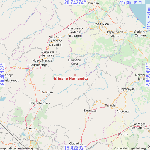
Bibiano Hernández GPS coordinates[2]
20° 5' 1.572" North, 97° 41' 53.124" West
| Map corner | latitude | longitude |
|---|---|---|
| Upper-left | 20.74274°, | -98.40122° |
| Center: | 20.08377°, | -97.69809° |
| Lower-right: | 19.42202°, | -96.99497° |
| Map W x H: | 146.9×146.9 km | = 91.3×91.3mi |
| max Lat: | 32.7° ⇑41.2% North |
| Bibiano Hernández: | 20.08377° |
| min Lat: | ⇓58.8% South 14.53588° |
| min Long | Bibiano Hernán | max Long |
| -117.105° | -97.69809° | -86.73105° |
| W 67.2%⇐ | ⇒32.8% E |
Elevation
Elevation of Bibiano Hernández is 882 m = 2894 ft, and this is 371.7 m = 1219 ft below average elevation for this country.
| Max E: |
3497 m = 11473 ft | 62% |
| Avg. | 1253.7 m = 4113 ft | |
| Bibiano Hernández | 882 m = 2894 ft | |
Min E: |
-1 m = -3 ft | 38% |
See also: Mexico elevation on elevation.city.
Geographical zone
Bibiano Hernández is located in North Torrid zone (between Equator and Tropic of Cancer). Distance of this Northern Tropic circle is 372.8 km =231.6 mi to North.| Distance of | km | miles | from Bibiano Hernández |
|---|---|---|---|
| North Pole | 7774 | 4830.5 | to North |
| Arctic Circle | 5168.1 | 3211.3 | to North |
| Tropic Cancer | 372.8 | 231.6 | to North |
| Equator | 2233.1 | 1387.6 | to South |


Nearby cities:
15 places around Bibiano Hernández: (largest is in red/bold)
• Bienvenido
6.5 km =4 mi,  311°
311°
• Chilocoyo del Carmen
4.5 km =2.8 mi,  95°
95°
• Chipahuatlán
2.7 km =1.7 mi,  158°
158°
• Coatepec
4.3 km =2.7 mi,  234°
234°
• Coyay
6 km =3.7 mi,  270°
270°
• Escatachuchut
7.1 km =4.4 mi,  116°
116°
• Hueytlalpan
6.3 km =3.9 mi,  178°
178°
• Ignacio Ramírez
4.7 km =2.9 mi, 312°
• Lacapan Camallagne
6.8 km =4.2 mi,  43°
43°
• Leacaman
6 km =3.7 mi,  73°
73°
• Lipuntahuaca
7.1 km =4.4 mi,  83°
83°
• Olintla
2.5 km =1.6 mi, 35°
• Pumacachocochuchut
6.4 km =4 mi,  55°
55°
• Vicente Guerrero
6.3 km =3.9 mi,  46°
46°
• Zitlala
6.3 km =3.9 mi,  149°
149°
Sources, notices
• [Note1] Compared only with cities in Mexico existing in our database
• [Src1] Map data: © OpenStreetMap contributors (CC-BY-SA)
• [Src2] Other city data from geonames.org with taken over terms of usage.
• [Src3] Geographical zone / Annual Mean Temperature by Robert A. Rohde @ Wikipedia
