Camocuautla geodata
Camocuautla (Puebla) is a populated place; located in Mexico in America/Mexico_City (GMT-6) time zone. With population of 1,412 people, there are 6125 cities with bigger population in this country. Compared to other cities in Mexico, 57.8% of cities are located further ↓South; 66.6% of cities are located further ←West and 64.5% of cities have higher elevation than Camocuautla. Note1


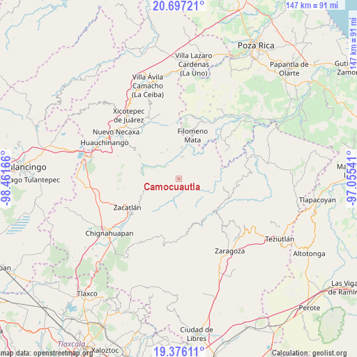
Camocuautla GPS coordinates[2]
20° 2' 16.98" North, 97° 45' 30.708" West
| Map corner | latitude | longitude |
|---|---|---|
| Upper-left | 20.69721°, | -98.46166° |
| Center: | 20.03805°, | -97.75853° |
| Lower-right: | 19.37611°, | -97.05541° |
| Map W x H: | 146.9×146.9 km | = 91.3×91.3mi |
| max Lat: | 32.7° ⇑42.2% North |
| Camocuautla: | 20.03805° |
| min Lat: | ⇓57.8% South 14.53588° |
| min Long | Camocuautla | max Long |
| -117.105° | -97.75853° | -86.73105° |
| W 66.6%⇐ | ⇒33.4% E |
Elevation
Elevation of Camocuautla is 716 m = 2349 ft, and this is 537.7 m = 1764 ft below average elevation for this country.
| Max E: |
3497 m = 11473 ft | 64.5% |
| Avg. | 1253.7 m = 4113 ft | |
| Camocuautla | 716 m = 2349 ft | |
Min E: |
-1 m = -3 ft | 35.5% |
See also: Mexico elevation on elevation.city.
Geographical zone
Camocuautla is located in North Torrid zone (between Equator and Tropic of Cancer). Distance of this Northern Tropic circle is 377.9 km =234.8 mi to North.| Distance of | km | miles | from Camocuautla |
|---|---|---|---|
| North Pole | 7779 | 4833.6 | to North |
| Arctic Circle | 5173.2 | 3214.5 | to North |
| Tropic Cancer | 377.9 | 234.8 | to North |
| Equator | 2228 | 1384.4 | to South |


Nearby cities:
15 places around Camocuautla: (largest is in red/bold)
• Altica
7.1 km =4.4 mi,  320°
320°
• Amixtlán
4.4 km =2.7 mi,  284°
284°
• Bibiano Hernández
8.1 km =5 mi,  51°
51°
• Chipahuatlán
7.7 km =4.8 mi,  70°
70°
• Coatepec
3.8 km =2.4 mi, 47°
• Coyay
5.1 km =3.2 mi,  3°
3°
• Cuautotola
5.3 km =3.3 mi,  309°
309°
• Hueytlalpan
6.5 km =4 mi,  100°
100°
• Jojupango (San Miguel Jojupango)
6.6 km =4.1 mi,  347°
347°
• Tapayula
2.7 km =1.7 mi,  145°
145°
• Tenepanigia (Santa Elena)
8.1 km =5 mi,  189°
189°
• Tepango
5.6 km =3.5 mi,  225°
225°
• Tlayehualancingo
7.1 km =4.4 mi,  265°
265°
• Zapotitlán
6.1 km =3.8 mi,  130°
130°
• Zongozotla
7.3 km =4.5 mi, 153°
Sources, notices
• [Note1] Compared only with cities in Mexico existing in our database
• [Src1] Map data: © OpenStreetMap contributors (CC-BY-SA)
• [Src2] Other city data from geonames.org with taken over terms of usage.
• [Src3] Geographical zone / Annual Mean Temperature by Robert A. Rohde @ Wikipedia
