San José Tilapa geodata
San José Tilapa (Puebla) is a populated place; located in Mexico in America/Mexico_City (GMT-6) time zone. With population of 2,081 people, there are 4197 cities with bigger population in this country. Compared to other cities in Mexico, 76.6% of cities are located further ↑North; 73.6% of cities are located further ←West and 61.3% of cities have higher elevation than San José Tilapa. Note1


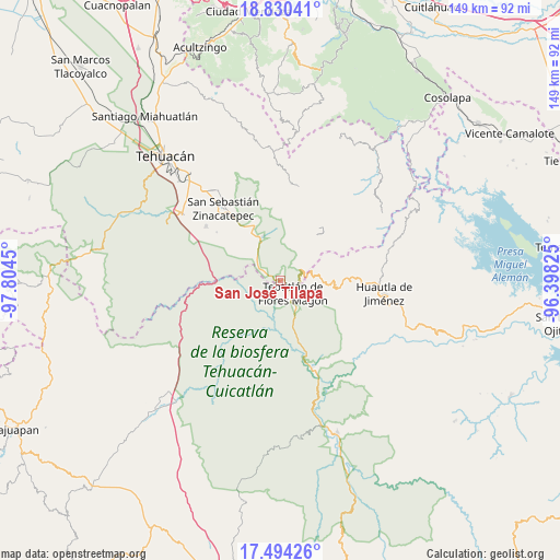
San José Tilapa GPS coordinates[2]
18° 9' 48.996" North, 97° 6' 4.932" West
| Map corner | latitude | longitude |
|---|---|---|
| Upper-left | 18.83041°, | -97.8045° |
| Center: | 18.16361°, | -97.10137° |
| Lower-right: | 17.49426°, | -96.39825° |
| Map W x H: | 148.6×148.6 km | = 92.3×92.3mi |
| max Lat: | 32.7° ⇑76.6% North |
| San José Tilapa: | 18.16361° |
| min Lat: | ⇓23.4% South 14.53588° |
| min Long | San José Tilap | max Long |
| -117.105° | -97.10137° | -86.73105° |
| W 73.6%⇐ | ⇒26.4% E |
Elevation
Elevation of San José Tilapa is 922 m = 3025 ft, and this is 331.7 m = 1088 ft below average elevation for this country.
| Max E: |
3497 m = 11473 ft | 61.3% |
| Avg. | 1253.7 m = 4113 ft | |
| San José Tilapa | 922 m = 3025 ft | |
Min E: |
-1 m = -3 ft | 38.7% |
See also: Mexico elevation on elevation.city.
Geographical zone
San José Tilapa is located in North Torrid zone (between Equator and Tropic of Cancer). Distance of this Northern Tropic circle is 586.3 km =364.3 mi to North.| Distance of | km | miles | from San José Tilapa |
|---|---|---|---|
| North Pole | 7987.5 | 4963.2 | to North |
| Arctic Circle | 5381.6 | 3344 | to North |
| Tropic Cancer | 586.3 | 364.3 | to North |
| Equator | 2019.6 | 1254.9 | to South |


Nearby cities:
15 places around San José Tilapa: (largest is in red/bold)
• Axuxco
13.4 km =8.3 mi,  303°
303°
• Chichiltepec
8.5 km =5.3 mi,  7°
7°
• Coxcatlán
12.6 km =7.8 mi,  335°
335°
• El Duraznillo
13.7 km =8.5 mi,  114°
114°
• Ignacio Mejía
7.4 km =4.6 mi,  190°
190°
• Nanahuatípam
4.1 km =2.5 mi,  217°
217°
• San Juan de los Cues
13.7 km =8.5 mi,  161°
161°
• Santa María Teopoxco
15.5 km =9.6 mi,  88°
88°
• Santiago Texcalcingo
14.9 km =9.3 mi,  70°
70°
• Tecuanapam
14.9 km =9.3 mi, 90°
• Teotitlán
4.8 km =3 mi,  137°
137°
• Tepantitlán
13.2 km =8.2 mi, 68°
• Tepoxtla
14.4 km =8.9 mi,  52°
52°
• Toxpalan
8.3 km =5.2 mi,  146°
146°
• Villa Nueva
12.9 km =8 mi,  82°
82°
Sources, notices
• [Note1] Compared only with cities in Mexico existing in our database
• [Src1] Map data: © OpenStreetMap contributors (CC-BY-SA)
• [Src2] Other city data from geonames.org with taken over terms of usage.
• [Src3] Geographical zone / Annual Mean Temperature by Robert A. Rohde @ Wikipedia
