Ixcotitlán geodata
Ixcotitlán (Hidalgo) is a populated place; located in Mexico in America/Mexico_City (GMT-6) time zone. With population of 548 people, there are 15532 cities with bigger population in this country. Compared to other cities in Mexico, 72.7% of cities are located further ↓South; 56.9% of cities are located further ←West and 55.3% of cities have higher elevation than Ixcotitlán. Note1


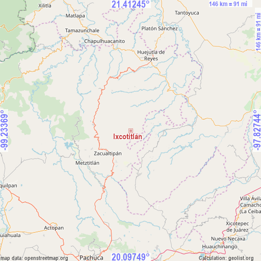
Ixcotitlán GPS coordinates[2]
20° 45' 23.04" North, 98° 31' 50.016" West
| Map corner | latitude | longitude |
|---|---|---|
| Upper-left | 21.41245°, | -99.23369° |
| Center: | 20.7564°, | -98.53056° |
| Lower-right: | 20.09749°, | -97.82744° |
| Map W x H: | 146.2×146.2 km | = 90.8×90.8mi |
| max Lat: | 32.7° ⇑27.3% North |
| Ixcotitlán: | 20.7564° |
| min Lat: | ⇓72.7% South 14.53588° |
| min Long | Ixcotitlán | max Long |
| -117.105° | -98.53056° | -86.73105° |
| W 56.9%⇐ | ⇒43.1% E |
Elevation
Elevation of Ixcotitlán is 1186 m = 3891 ft, and this is 67.7 m = 222 ft below average elevation for this country.
| Max E: |
3497 m = 11473 ft | 55.3% |
| Avg. | 1253.7 m = 4113 ft | |
| Ixcotitlán | 1186 m = 3891 ft | |
Min E: |
-1 m = -3 ft | 44.7% |
See also: Mexico elevation on elevation.city.
Geographical zone
Ixcotitlán is located in North Torrid zone (between Equator and Tropic of Cancer). Distance of this Northern Tropic circle is 298 km =185.2 mi to North.| Distance of | km | miles | from Ixcotitlán |
|---|---|---|---|
| North Pole | 7699.2 | 4784.1 | to North |
| Arctic Circle | 5093.3 | 3164.8 | to North |
| Tropic Cancer | 298 | 185.2 | to North |
| Equator | 2307.9 | 1434.1 | to South |


Nearby cities:
15 places around Ixcotitlán: (largest is in red/bold)
• Apachitla
6.3 km =3.9 mi,  121°
121°
• Atempa
11.9 km =7.4 mi,  90°
90°
• Coatlila
9.7 km =6 mi,  216°
216°
• Ilamatlán
9.5 km =5.9 mi,  73°
73°
• Jalapa
9.4 km =5.8 mi,  170°
170°
• Polintotla
2.6 km =1.6 mi, 68°
• San Miguel
7.4 km =4.6 mi,  346°
346°
• San Pablo Mitecatlán
5.6 km =3.5 mi, 170°
• Soyatla
11 km =6.8 mi,  232°
232°
• Tecapa
7.5 km =4.7 mi,  109°
109°
• Tianguistengo
11 km =6.8 mi,  253°
253°
• Tuzancoac
11.2 km =7 mi, 347°
• Xalacahuantla
5.2 km =3.2 mi,  49°
49°
• Xochimilco
3.8 km =2.4 mi,  29°
29°
• Zacatipán
9.3 km =5.8 mi,  12°
12°
Sources, notices
• [Note1] Compared only with cities in Mexico existing in our database
• [Src1] Map data: © OpenStreetMap contributors (CC-BY-SA)
• [Src2] Other city data from geonames.org with taken over terms of usage.
• [Src3] Geographical zone / Annual Mean Temperature by Robert A. Rohde @ Wikipedia
