Chunchintok geodata
Chunchintok (Campeche) is a populated place; located in Mexico in America/Merida (GMT-6) time zone. With population of 1,086 people, there are 8018 cities with bigger population in this country. Compared to other cities in Mexico, 57.3% of cities are located further ↑North; 98% of cities are located further ←West and 77.5% of cities have higher elevation than Chunchintok. Note1


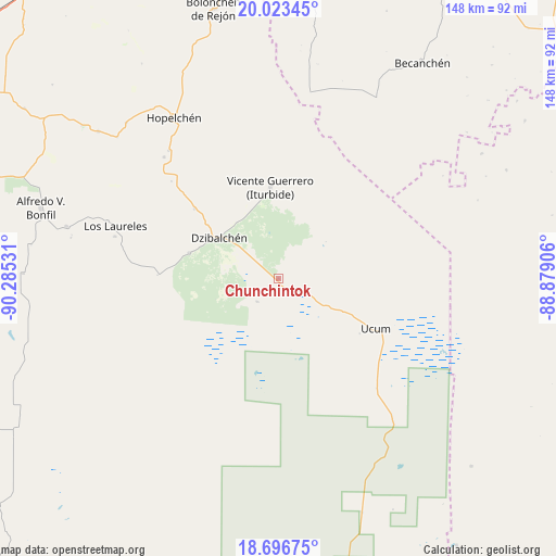
Chunchintok GPS coordinates[2]
19° 21' 41.22" North, 89° 34' 55.848" West
| Map corner | latitude | longitude |
|---|---|---|
| Upper-left | 20.02345°, | -90.28531° |
| Center: | 19.36145°, | -89.58218° |
| Lower-right: | 18.69675°, | -88.87906° |
| Map W x H: | 147.5×147.5 km | = 91.7×91.7mi |
| max Lat: | 32.7° ⇑57.3% North |
| Chunchintok: | 19.36145° |
| min Lat: | ⇓42.7% South 14.53588° |
| min Long | Chunchintok | max Long |
| -117.105° | -89.58218° | -86.73105° |
| W 98%⇐ | ⇒2% E |
Elevation
Elevation of Chunchintok is 142 m = 466 ft, and this is 1111.7 m = 3647 ft below average elevation for this country.
| Max E: |
3497 m = 11473 ft | 77.5% |
| Avg. | 1253.7 m = 4113 ft | |
| Chunchintok | 142 m = 466 ft | |
Min E: |
-1 m = -3 ft | 22.5% |
See also: Mexico elevation on elevation.city.
Geographical zone
Chunchintok is located in North Torrid zone (between Equator and Tropic of Cancer). Distance of this Northern Tropic circle is 453.1 km =281.5 mi to North.| Distance of | km | miles | from Chunchintok |
|---|---|---|---|
| North Pole | 7854.3 | 4880.4 | to North |
| Arctic Circle | 5248.4 | 3261.2 | to North |
| Tropic Cancer | 453.1 | 281.5 | to North |
| Equator | 2152.8 | 1337.7 | to South |


Nearby cities:
15 places around Chunchintok: (largest is in red/bold)
• Cancabchén
8.2 km =5.1 mi,  221°
221°
• Crucero San Luis
56.9 km =35.4 mi,  311°
311°
• Dzibalchén
19 km =11.8 mi,  304°
304°
• Hopelchén
50.9 km =31.6 mi,  327°
327°
• Ich-Ek
57.7 km =35.9 mi,  315°
315°
• Iturbide
24.3 km =15.1 mi,  355°
355°
• Konchén
38.3 km =23.8 mi, 312°
• Los Laureles
45.5 km =28.3 mi,  288°
288°
• Pich
57.9 km =36 mi,  283°
283°
• Quetzal Edzná
55.9 km =34.7 mi, 281°
• Santa Rita
44.2 km =27.5 mi, 316°
• Suc-Tuc
61.7 km =38.3 mi, 309°
• Ukúm
29.1 km =18.1 mi,  117°
117°
• Xcupil
44.6 km =27.7 mi, 319°
• Xmabén
31.4 km =19.5 mi, 116°
Sources, notices
• [Note1] Compared only with cities in Mexico existing in our database
• [Src1] Map data: © OpenStreetMap contributors (CC-BY-SA)
• [Src2] Other city data from geonames.org with taken over terms of usage.
• [Src3] Geographical zone / Annual Mean Temperature by Robert A. Rohde @ Wikipedia
