Tekát geodata
Tekát (Yucatán) is a populated place; located in Mexico in America/Merida (GMT-6) time zone. With population of 579 people, there are 14804 cities with bigger population in this country. Compared to other cities in Mexico, 77.8% of cities are located further ↓South; 98.1% of cities are located further ←West and 98.1% of cities have higher elevation than Tekát. Note1


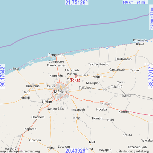
Tekát GPS coordinates[2]
21° 5' 48.192" North, 89° 28' 23.844" West
| Map corner | latitude | longitude |
|---|---|---|
| Upper-left | 21.75126°, | -90.17642° |
| Center: | 21.09672°, | -89.47329° |
| Lower-right: | 20.43929°, | -88.77017° |
| Map W x H: | 145.9×145.9 km | = 90.7×90.7mi |
| max Lat: | 32.7° ⇑22.2% North |
| Tekát: | 21.09672° |
| min Lat: | ⇓77.8% South 14.53588° |
| min Long | Tekát | max Long |
| -117.105° | -89.47329° | -86.73105° |
| W 98.1%⇐ | ⇒1.9% E |
Elevation
Elevation of Tekát is 8 m = 26 ft, and this is 1245.7 m = 4087 ft below average elevation for this country.
| Max E: |
3497 m = 11473 ft | 98.1% |
| Avg. | 1253.7 m = 4113 ft | |
| Tekát | 8 m = 26 ft | |
Min E: |
-1 m = -3 ft | 1.9% |
See also: Mexico elevation on elevation.city.
Geographical zone
Tekát is located in North Torrid zone (between Equator and Tropic of Cancer). Distance of this Northern Tropic circle is 260.2 km =161.7 mi to North.| Distance of | km | miles | from Tekát |
|---|---|---|---|
| North Pole | 7661.3 | 4760.5 | to North |
| Arctic Circle | 5055.4 | 3141.3 | to North |
| Tropic Cancer | 260.2 | 161.7 | to North |
| Equator | 2345.7 | 1457.5 | to South |


Nearby cities:
15 places around Tekát: (largest is in red/bold)
• Baca
7.9 km =4.9 mi,  80°
80°
• Chablekal
10.8 km =6.7 mi,  269°
269°
• Chicxulub Pueblo
6.3 km =3.9 mi,  314°
314°
• Chochoh
11.5 km =7.1 mi,  176°
176°
• Cholul
10.7 km =6.6 mi,  235°
235°
• Conkal
5.5 km =3.4 mi, 242°
• Ixil
6.2 km =3.9 mi,  351°
351°
• Mococha
2.4 km =1.5 mi,  64°
64°
• Nolo
11 km =6.8 mi,  151°
151°
• Sitpach
9.3 km =5.8 mi,  212°
212°
• Timul
13.7 km =8.5 mi,  38°
38°
• Tixkokob
13.3 km =8.3 mi,  142°
142°
• Tixkunchell
8.1 km =5 mi,  103°
103°
• Tixpehual
13.7 km =8.5 mi,  166°
166°
• Yaxkukul
6.8 km =4.2 mi,  125°
125°
Sources, notices
• [Note1] Compared only with cities in Mexico existing in our database
• [Src1] Map data: © OpenStreetMap contributors (CC-BY-SA)
• [Src2] Other city data from geonames.org with taken over terms of usage.
• [Src3] Geographical zone / Annual Mean Temperature by Robert A. Rohde @ Wikipedia
