Xochitepec geodata
Xochitepec (Puebla) is a populated place; located in Mexico in America/Mexico_City (GMT-6) time zone. With population of 1,135 people, there are 7645 cities with bigger population in this country. Compared to other cities in Mexico, 75.8% of cities are located further ↑North; 52.3% of cities are located further ←West and 51% of cities have higher elevation than Xochitepec. Note1


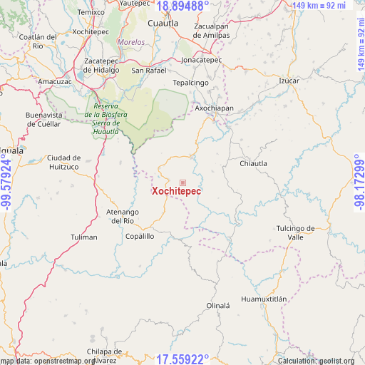
Xochitepec GPS coordinates[2]
18° 13' 41.988" North, 98° 52' 33.996" West
| Map corner | latitude | longitude |
|---|---|---|
| Upper-left | 18.89488°, | -99.57924° |
| Center: | 18.22833°, | -98.87611° |
| Lower-right: | 17.55922°, | -98.17299° |
| Map W x H: | 148.5×148.5 km | = 92.3×92.3mi |
| max Lat: | 32.7° ⇑75.8% North |
| Xochitepec: | 18.22833° |
| min Lat: | ⇓24.2% South 14.53588° |
| min Long | Xochitepec | max Long |
| -117.105° | -98.87611° | -86.73105° |
| W 52.3%⇐ | ⇒47.7% E |
Elevation
Elevation of Xochitepec is 1382 m = 4534 ft, and this is 128.3 m = 421 ft above average elevation for this country.
| Max E: |
3497 m = 11473 ft | 51% |
| Xochitepec | 1382 m 4534 ft | |
| Avg. | 1253.7 m = 4113 ft | |
Min E: |
-1 m = -3 ft | 49% |
See also: Mexico elevation on elevation.city.
Geographical zone
Xochitepec is located in North Torrid zone (between Equator and Tropic of Cancer). Distance of this Northern Tropic circle is 579.1 km =359.8 mi to North.| Distance of | km | miles | from Xochitepec |
|---|---|---|---|
| North Pole | 7980.3 | 4958.7 | to North |
| Arctic Circle | 5374.4 | 3339.5 | to North |
| Tropic Cancer | 579.1 | 359.8 | to North |
| Equator | 2026.8 | 1259.4 | to South |


Nearby cities:
15 places around Xochitepec: (largest is in red/bold)
• Atenango del Río
28 km =17.4 mi,  240°
240°
• Ayoxuxtla
13 km =8.1 mi,  69°
69°
• Chaucingo
26.5 km =16.5 mi,  287°
287°
• Coacalco
28.1 km =17.5 mi,  128°
128°
• Copalillo
27.7 km =17.2 mi,  218°
218°
• El Cascalote
23.1 km =14.4 mi,  230°
230°
• Huachinantla
11.4 km =7.1 mi,  301°
301°
• Huehuetlan el Chico
25.4 km =15.8 mi,  50°
50°
• Jolalpan
11.2 km =7 mi,  17°
17°
• Mezquitlán
23.9 km =14.9 mi,  195°
195°
• Pilcaya (San Juan Pilcaya)
17.9 km =11.1 mi,  86°
86°
• Santa Mónica
8 km =5 mi,  105°
105°
• Temalac de Morelos
14.9 km =9.3 mi,  213°
213°
• Teutla
10.2 km =6.3 mi,  312°
312°
• Tzicatlán
27.8 km =17.3 mi,  27°
27°
Sources, notices
• [Note1] Compared only with cities in Mexico existing in our database
• [Src1] Map data: © OpenStreetMap contributors (CC-BY-SA)
• [Src2] Other city data from geonames.org with taken over terms of usage.
• [Src3] Geographical zone / Annual Mean Temperature by Robert A. Rohde @ Wikipedia
