Ahuelicán geodata
Ahuelicán (Guerrero) is a populated place; located in Mexico in America/Mexico_City (GMT-6) time zone. With population of 567 people, there are 15067 cities with bigger population in this country. Compared to other cities in Mexico, 78.4% of cities are located further ↑North; 56.6% of cities are located further →East and 63.4% of cities have higher elevation than Ahuelicán. Note1


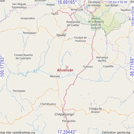
Ahuelicán GPS coordinates[2]
18° 1' 27.516" North, 99° 28' 29.28" West
| Map corner | latitude | longitude |
|---|---|---|
| Upper-left | 18.69165°, | -100.17793° |
| Center: | 18.02431°, | -99.4748° |
| Lower-right: | 17.35443°, | -98.77168° |
| Map W x H: | 148.7×148.7 km | = 92.4×92.4mi |
| max Lat: | 32.7° ⇑78.4% North |
| Ahuelicán: | 18.02431° |
| min Lat: | ⇓21.6% South 14.53588° |
| min Long | Ahuelicán | max Long |
| -117.105° | -99.4748° | -86.73105° |
| W 43.4%⇐ | ⇒56.6% E |
Elevation
Elevation of Ahuelicán is 790 m = 2592 ft, and this is 463.7 m = 1521 ft below average elevation for this country.
| Max E: |
3497 m = 11473 ft | 63.4% |
| Avg. | 1253.7 m = 4113 ft | |
| Ahuelicán | 790 m = 2592 ft | |
Min E: |
-1 m = -3 ft | 36.6% |
See also: Mexico elevation on elevation.city.
Geographical zone
Ahuelicán is located in North Torrid zone (between Equator and Tropic of Cancer). Distance of this Northern Tropic circle is 601.8 km =373.9 mi to North.| Distance of | km | miles | from Ahuelicán |
|---|---|---|---|
| North Pole | 8002.9 | 4972.8 | to North |
| Arctic Circle | 5397.1 | 3353.6 | to North |
| Tropic Cancer | 601.8 | 373.9 | to North |
| Equator | 2004.1 | 1245.3 | to South |


Nearby cities:
15 places around Ahuelicán: (largest is in red/bold)
• Ahuehuepan
3.3 km =2.1 mi,  232°
232°
• Ameyaltepec
7.4 km =4.6 mi,  208°
208°
• Maxela
13.1 km =8.1 mi,  284°
284°
• Mezcala
16.9 km =10.5 mi, 232°
• Palula
10.5 km =6.5 mi,  319°
319°
• Sabana Grande
16.8 km =10.4 mi,  332°
332°
• San Agustín Oapan
8.9 km =5.5 mi,  154°
154°
• San Juan Tetelcingo
12.3 km =7.6 mi,  202°
202°
• San Marcos Oacatzingo
10 km =6.2 mi,  184°
184°
• San Miguel Tecuiciapan
9.4 km =5.8 mi,  137°
137°
• Tlamamacan
12.5 km =7.8 mi, 205°
• Tonalapa del Sur
12.1 km =7.5 mi,  312°
312°
• Tula del Río
16.3 km =10.1 mi,  132°
132°
• Venta de Palula
12.5 km =7.8 mi, 320°
• Xalitla
7.9 km =4.9 mi,  247°
247°
Sources, notices
• [Note1] Compared only with cities in Mexico existing in our database
• [Src1] Map data: © OpenStreetMap contributors (CC-BY-SA)
• [Src2] Other city data from geonames.org with taken over terms of usage.
• [Src3] Geographical zone / Annual Mean Temperature by Robert A. Rohde @ Wikipedia
