Ameyaltepec geodata
Ameyaltepec (Guerrero) is a populated place; located in Mexico in America/Mexico_City (GMT-6) time zone. With population of 951 people, there are 9161 cities with bigger population in this country. Compared to other cities in Mexico, 79% of cities are located further ↑North; 57.1% of cities are located further →East and 61.9% of cities have higher elevation than Ameyaltepec. Note1


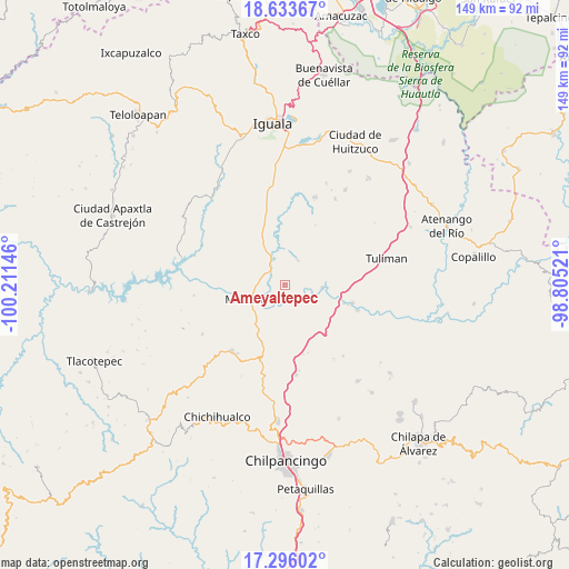
Ameyaltepec GPS coordinates[2]
17° 57' 57.996" North, 99° 30' 29.988" West
| Map corner | latitude | longitude |
|---|---|---|
| Upper-left | 18.63367°, | -100.21146° |
| Center: | 17.96611°, | -99.50833° |
| Lower-right: | 17.29602°, | -98.80521° |
| Map W x H: | 148.7×148.7 km | = 92.4×92.4mi |
| max Lat: | 32.7° ⇑79% North |
| Ameyaltepec: | 17.96611° |
| min Lat: | ⇓21% South 14.53588° |
| min Long | Ameyaltepec | max Long |
| -117.105° | -99.50833° | -86.73105° |
| W 42.9%⇐ | ⇒57.1% E |
Elevation
Elevation of Ameyaltepec is 883 m = 2897 ft, and this is 370.7 m = 1216 ft below average elevation for this country.
| Max E: |
3497 m = 11473 ft | 61.9% |
| Avg. | 1253.7 m = 4113 ft | |
| Ameyaltepec | 883 m = 2897 ft | |
Min E: |
-1 m = -3 ft | 38.1% |
See also: Mexico elevation on elevation.city.
Geographical zone
Ameyaltepec is located in North Torrid zone (between Equator and Tropic of Cancer). Distance of this Northern Tropic circle is 608.3 km =378 mi to North.| Distance of | km | miles | from Ameyaltepec |
|---|---|---|---|
| North Pole | 8009.4 | 4976.8 | to North |
| Arctic Circle | 5403.5 | 3357.6 | to North |
| Tropic Cancer | 608.3 | 378 | to North |
| Equator | 1997.6 | 1241.3 | to South |


Nearby cities:
15 places around Ameyaltepec: (largest is in red/bold)
• Ahuehuepan
4.6 km =2.9 mi,  11°
11°
• Ahuelicán
7.4 km =4.6 mi,  28°
28°
• Atzcala
16.4 km =10.2 mi,  274°
274°
• Maxela
13.3 km =8.3 mi,  316°
316°
• Mezcala
10.6 km =6.6 mi,  249°
249°
• Palula
14.8 km =9.2 mi,  347°
347°
• San Agustín Oapan
7.6 km =4.7 mi,  101°
101°
• San Juan Tetelcingo
5 km =3.1 mi,  192°
192°
• San Marcos Oacatzingo
4.5 km =2.8 mi,  141°
141°
• San Miguel Tecuiciapan
9.9 km =6.2 mi,  92°
92°
• Tlamamacan
5.2 km =3.2 mi,  201°
201°
• Tonalapa del Sur
15.6 km =9.7 mi,  339°
339°
• Tula del Río
16.2 km =10.1 mi,  106°
106°
• Venta de Palula
16.7 km =10.4 mi, 344°
• Xalitla
5.2 km =3.2 mi,  312°
312°
Sources, notices
• [Note1] Compared only with cities in Mexico existing in our database
• [Src1] Map data: © OpenStreetMap contributors (CC-BY-SA)
• [Src2] Other city data from geonames.org with taken over terms of usage.
• [Src3] Geographical zone / Annual Mean Temperature by Robert A. Rohde @ Wikipedia
