Mezcala geodata
Mezcala (Guerrero) is a populated place; located in Mexico in America/Mexico_City (GMT-6) time zone. With population of 3,763 people, there are 2436 cities with bigger population in this country. Compared to other cities in Mexico, 79.3% of cities are located further ↑North; 58.6% of cities are located further →East and 68.6% of cities have higher elevation than Mezcala. Note1


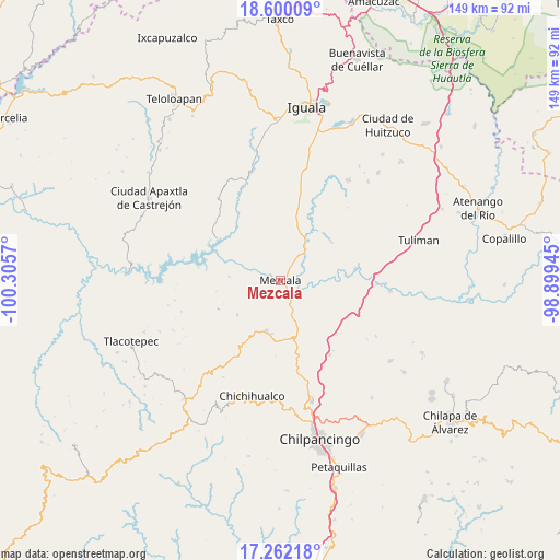
Mezcala GPS coordinates[2]
17° 55' 56.64" North, 99° 36' 9.252" West
| Map corner | latitude | longitude |
|---|---|---|
| Upper-left | 18.60009°, | -100.3057° |
| Center: | 17.9324°, | -99.60257° |
| Lower-right: | 17.26218°, | -98.89945° |
| Map W x H: | 148.8×148.8 km | = 92.5×92.5mi |
| max Lat: | 32.7° ⇑79.3% North |
| Mezcala: | 17.9324° |
| min Lat: | ⇓20.7% South 14.53588° |
| min Long | Mezcala | max Long |
| -117.105° | -99.60257° | -86.73105° |
| W 41.4%⇐ | ⇒58.6% E |
Elevation
Elevation of Mezcala is 494 m = 1621 ft, and this is 759.7 m = 2492 ft below average elevation for this country.
| Max E: |
3497 m = 11473 ft | 68.6% |
| Avg. | 1253.7 m = 4113 ft | |
| Mezcala | 494 m = 1621 ft | |
Min E: |
-1 m = -3 ft | 31.4% |
See also: Mexico elevation on elevation.city.
Geographical zone
Mezcala is located in North Torrid zone (between Equator and Tropic of Cancer). Distance of this Northern Tropic circle is 612 km =380.3 mi to North.| Distance of | km | miles | from Mezcala |
|---|---|---|---|
| North Pole | 8013.2 | 4979.2 | to North |
| Arctic Circle | 5407.3 | 3359.9 | to North |
| Tropic Cancer | 612 | 380.3 | to North |
| Equator | 1993.9 | 1239 | to South |


Nearby cities:
15 places around Mezcala: (largest is in red/bold)
• Ahuehuepan
13.6 km =8.5 mi,  52°
52°
• Ahuelicán
16.9 km =10.5 mi, 52°
• Ameyaltepec
10.6 km =6.6 mi,  69°
69°
• Atzcala
8.1 km =5 mi,  308°
308°
• Carrizalillo
14.8 km =9.2 mi,  232°
232°
• Coacoyula de Álvarez
16.3 km =10.1 mi,  349°
349°
• Maxela
13.5 km =8.4 mi,  3°
3°
• Palula
19.4 km =12.1 mi,  20°
20°
• San Agustín Oapan
17.5 km =10.9 mi,  82°
82°
• San Juan Tetelcingo
9 km =5.6 mi,  97°
97°
• San Marcos Oacatzingo
12.8 km =8 mi,  88°
88°
• Tlamamacan
8.1 km =5 mi, 97°
• Tonalapa del Sur
18.9 km =11.7 mi,  13°
13°
• Xalitla
9.5 km =5.9 mi,  40°
40°
• Xochipala
14 km =8.7 mi,  196°
196°
Sources, notices
• [Note1] Compared only with cities in Mexico existing in our database
• [Src1] Map data: © OpenStreetMap contributors (CC-BY-SA)
• [Src2] Other city data from geonames.org with taken over terms of usage.
• [Src3] Geographical zone / Annual Mean Temperature by Robert A. Rohde @ Wikipedia
