Tlamamacan geodata
Tlamamacan (Guerrero) is a populated place; located in Mexico in America/Mexico_City (GMT-6) time zone. With population of 620 people, there are 13925 cities with bigger population in this country. Compared to other cities in Mexico, 79.4% of cities are located further ↑North; 57.3% of cities are located further →East and 68.5% of cities have higher elevation than Tlamamacan. Note1


Tlamamacan GPS coordinates[2]
17° 55' 22.008" North, 99° 31' 35.004" West
| Map corner | latitude | longitude |
|---|---|---|
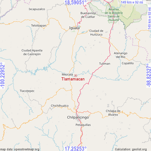
| Upper-left | 18.59051°, | -100.22952° |
| Center: | 17.92278°, | -99.52639° |
| Lower-right: | 17.25253°, | -98.82327° |
| Map W x H: | 148.8×148.8 km | = 92.5×92.5mi |
| max Lat: | 32.7° ⇑79.4% North |
| Tlamamacan: | 17.92278° |
| min Lat: | ⇓20.6% South 14.53588° |
| min Long | Tlamamacan | max Long |
| -117.105° | -99.52639° | -86.73105° |
| W 42.7%⇐ | ⇒57.3% E |
Elevation
Elevation of Tlamamacan is 496 m = 1627 ft, and this is 757.7 m = 2486 ft below average elevation for this country.
| Max E: |
3497 m = 11473 ft | 68.5% |
| Avg. | 1253.7 m = 4113 ft | |
| Tlamamacan | 496 m = 1627 ft | |
Min E: |
-1 m = -3 ft | 31.5% |
See also: Mexico elevation on elevation.city.
Geographical zone
Tlamamacan is located in North Torrid zone (between Equator and Tropic of Cancer). Distance of this Northern Tropic circle is 613.1 km =381 mi to North.| Distance of | km | miles | from Tlamamacan |
|---|---|---|---|
| North Pole | 8014.2 | 4979.8 | to North |
| Arctic Circle | 5408.3 | 3360.6 | to North |
| Tropic Cancer | 613.1 | 381 | to North |
| Equator | 1992.8 | 1238.3 | to South |


Nearby cities:
15 places around Tlamamacan: (largest is in red/bold)
• Ahuehuepan
9.7 km =6 mi,  16°
16°
• Ahuelicán
12.5 km =7.8 mi,  25°
25°
• Ameyaltepec
5.2 km =3.2 mi, 21°
• Atzcala
15.7 km =9.8 mi,  292°
292°
• Axaxacualco
14.9 km =9.3 mi,  152°
152°
• Maxela
16.2 km =10.1 mi,  333°
333°
• Mezcala
8.1 km =5 mi,  277°
277°
• San Agustín Oapan
9.9 km =6.2 mi,  70°
70°
• San Juan Tetelcingo
0.9 km =0.6 mi,  96°
96°
• San Marcos Oacatzingo
4.9 km =3 mi, 74°
• San Miguel Tecuiciapan
12.6 km =7.8 mi, 69°
• Tlanipatla
15 km =9.3 mi, 148°
• Tula del Río
17.5 km =10.9 mi,  89°
89°
• Xalitla
8.5 km =5.3 mi,  347°
347°
• Xochipala
17.2 km =10.7 mi,  224°
224°
Sources, notices
• [Note1] Compared only with cities in Mexico existing in our database
• [Src1] Map data: © OpenStreetMap contributors (CC-BY-SA)
• [Src2] Other city data from geonames.org with taken over terms of usage.
• [Src3] Geographical zone / Annual Mean Temperature by Robert A. Rohde @ Wikipedia
