Acoyotla geodata
Acoyotla (Hidalgo) is a populated place; located in Mexico in America/Mexico_City (GMT-6) time zone. With population of 1,958 people, there are 4449 cities with bigger population in this country. Compared to other cities in Mexico, 78.2% of cities are located further ↓South; 54% of cities are located further ←West and 62% of cities have higher elevation than Acoyotla. Note1


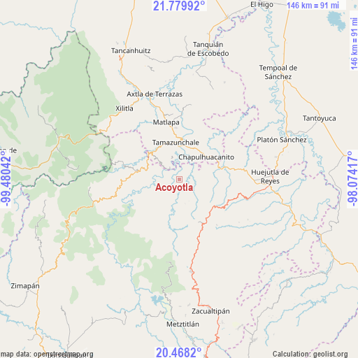
Acoyotla GPS coordinates[2]
21° 7' 31.836" North, 98° 46' 38.244" West
| Map corner | latitude | longitude |
|---|---|---|
| Upper-left | 21.77992°, | -99.48042° |
| Center: | 21.12551°, | -98.77729° |
| Lower-right: | 20.4682°, | -98.07417° |
| Map W x H: | 145.8×145.9 km | = 90.6×90.7mi |
| max Lat: | 32.7° ⇑21.8% North |
| Acoyotla: | 21.12551° |
| min Lat: | ⇓78.2% South 14.53588° |
| min Long | Acoyotla | max Long |
| -117.105° | -98.77729° | -86.73105° |
| W 54%⇐ | ⇒46% E |
Elevation
Elevation of Acoyotla is 881 m = 2890 ft, and this is 372.7 m = 1223 ft below average elevation for this country.
| Max E: |
3497 m = 11473 ft | 62% |
| Avg. | 1253.7 m = 4113 ft | |
| Acoyotla | 881 m = 2890 ft | |
Min E: |
-1 m = -3 ft | 38% |
See also: Mexico elevation on elevation.city.
Geographical zone
Acoyotla is located in North Torrid zone (between Equator and Tropic of Cancer). Distance of this Northern Tropic circle is 257 km =159.7 mi to North.| Distance of | km | miles | from Acoyotla |
|---|---|---|---|
| North Pole | 7658.1 | 4758.5 | to North |
| Arctic Circle | 5052.2 | 3139.3 | to North |
| Tropic Cancer | 257 | 159.7 | to North |
| Equator | 2348.9 | 1459.5 | to South |


Nearby cities:
15 places around Acoyotla: (largest is in red/bold)
• Axhumol
8.7 km =5.4 mi,  357°
357°
• Cahuazas
8.2 km =5.1 mi,  281°
281°
• Cahuazaz de Morelos (Rancho Alegre)
7.1 km =4.4 mi,  295°
295°
• Chahuatitla
6.8 km =4.2 mi,  264°
264°
• Chantasco
5.7 km =3.5 mi,  30°
30°
• Cuatolol
5.1 km =3.2 mi, 262°
• Jalpa
6.9 km =4.3 mi,  105°
105°
• Santa Lucía
8.4 km =5.2 mi,  60°
60°
• Tezapotla
6.5 km =4 mi,  325°
325°
• Tixcuayuca
7.4 km =4.6 mi, 331°
• Tlachiquilillacapa
8.4 km =5.2 mi,  308°
308°
• Xalcuatla
6.6 km =4.1 mi,  13°
13°
• Xilitla
6.9 km =4.3 mi,  206°
206°
• Xuchitlán
7.7 km =4.8 mi,  153°
153°
• Zacualtipanito
4 km =2.5 mi,  323°
323°
Sources, notices
• [Note1] Compared only with cities in Mexico existing in our database
• [Src1] Map data: © OpenStreetMap contributors (CC-BY-SA)
• [Src2] Other city data from geonames.org with taken over terms of usage.
• [Src3] Geographical zone / Annual Mean Temperature by Robert A. Rohde @ Wikipedia
