Axhumol geodata
Axhumol (San Luis Potosí) is a populated place; located in Mexico in America/Mexico_City (GMT-6) time zone. With population of 995 people, there are 8755 cities with bigger population in this country. Compared to other cities in Mexico, 79.2% of cities are located further ↓South; 53.9% of cities are located further ←West and 77.3% of cities have higher elevation than Axhumol. Note1


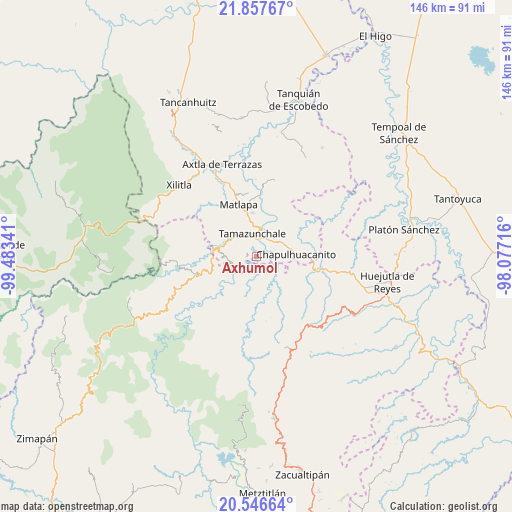
Axhumol GPS coordinates[2]
21° 12' 12.996" North, 98° 46' 49.008" West
| Map corner | latitude | longitude |
|---|---|---|
| Upper-left | 21.85767°, | -99.48341° |
| Center: | 21.20361°, | -98.78028° |
| Lower-right: | 20.54664°, | -98.07716° |
| Map W x H: | 145.8×145.8 km | = 90.6×90.6mi |
| max Lat: | 32.7° ⇑20.8% North |
| Axhumol: | 21.20361° |
| min Lat: | ⇓79.2% South 14.53588° |
| min Long | Axhumol | max Long |
| -117.105° | -98.78028° | -86.73105° |
| W 53.9%⇐ | ⇒46.1% E |
Elevation
Elevation of Axhumol is 147 m = 482 ft, and this is 1106.7 m = 3631 ft below average elevation for this country.
| Max E: |
3497 m = 11473 ft | 77.3% |
| Avg. | 1253.7 m = 4113 ft | |
| Axhumol | 147 m = 482 ft | |
Min E: |
-1 m = -3 ft | 22.7% |
See also: Mexico elevation on elevation.city.
Geographical zone
Axhumol is located in North Torrid zone (between Equator and Tropic of Cancer). Distance of this Northern Tropic circle is 248.3 km =154.3 mi to North.| Distance of | km | miles | from Axhumol |
|---|---|---|---|
| North Pole | 7649.4 | 4753.1 | to North |
| Arctic Circle | 5043.6 | 3133.9 | to North |
| Tropic Cancer | 248.3 | 154.3 | to North |
| Equator | 2357.6 | 1464.9 | to South |


Nearby cities:
15 places around Axhumol: (largest is in red/bold)
• Atlajque
2.7 km =1.7 mi,  294°
294°
• Chantasco
4.9 km =3 mi,  139°
139°
• Coaxocotitla
1.1 km =0.7 mi,  45°
45°
• Enramaditas
2.8 km =1.7 mi,  266°
266°
• Mecatlán
2.2 km =1.4 mi,  323°
323°
• Pemucho
5.2 km =3.2 mi,  262°
262°
• Rancho Nuevo
5.6 km =3.5 mi,  93°
93°
• Santa María Picula
3.7 km =2.3 mi, 92°
• Tamacol
5.8 km =3.6 mi,  306°
306°
• Temamatla
3.9 km =2.4 mi,  28°
28°
• Tetitla
5.4 km =3.4 mi,  278°
278°
• Tezapotla
4.7 km =2.9 mi,  225°
225°
• Tixcuayuca
3.9 km =2.4 mi,  236°
236°
• Xalcuatla
2.9 km =1.8 mi, 140°
• Zacualtipanito
5.9 km =3.7 mi,  200°
200°
Sources, notices
• [Note1] Compared only with cities in Mexico existing in our database
• [Src1] Map data: © OpenStreetMap contributors (CC-BY-SA)
• [Src2] Other city data from geonames.org with taken over terms of usage.
• [Src3] Geographical zone / Annual Mean Temperature by Robert A. Rohde @ Wikipedia
