Xalcuatla geodata
Xalcuatla (Hidalgo) is a populated place; located in Mexico in America/Mexico_City (GMT-6) time zone. With population of 778 people, there are 11229 cities with bigger population in this country. Compared to other cities in Mexico, 79% of cities are located further ↓South; 54.2% of cities are located further ←West and 71% of cities have higher elevation than Xalcuatla. Note1


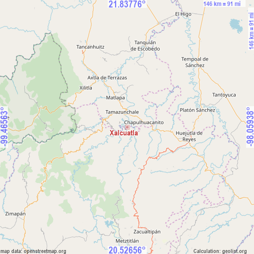
Xalcuatla GPS coordinates[2]
21° 11' 0.996" North, 98° 45' 45" West
| Map corner | latitude | longitude |
|---|---|---|
| Upper-left | 21.83776°, | -99.46563° |
| Center: | 21.18361°, | -98.7625° |
| Lower-right: | 20.52656°, | -98.05938° |
| Map W x H: | 145.8×145.8 km | = 90.6×90.6mi |
| max Lat: | 32.7° ⇑21% North |
| Xalcuatla: | 21.18361° |
| min Lat: | ⇓79% South 14.53588° |
| min Long | Xalcuatla | max Long |
| -117.105° | -98.7625° | -86.73105° |
| W 54.2%⇐ | ⇒45.8% E |
Elevation
Elevation of Xalcuatla is 370 m = 1214 ft, and this is 883.7 m = 2899 ft below average elevation for this country.
| Max E: |
3497 m = 11473 ft | 71% |
| Avg. | 1253.7 m = 4113 ft | |
| Xalcuatla | 370 m = 1214 ft | |
Min E: |
-1 m = -3 ft | 29% |
See also: Mexico elevation on elevation.city.
Geographical zone
Xalcuatla is located in North Torrid zone (between Equator and Tropic of Cancer). Distance of this Northern Tropic circle is 250.5 km =155.7 mi to North.| Distance of | km | miles | from Xalcuatla |
|---|---|---|---|
| North Pole | 7651.7 | 4754.5 | to North |
| Arctic Circle | 5045.8 | 3135.3 | to North |
| Tropic Cancer | 250.5 | 155.7 | to North |
| Equator | 2355.4 | 1463.6 | to South |


Nearby cities:
15 places around Xalcuatla: (largest is in red/bold)
• Atlajque
5.5 km =3.4 mi,  307°
307°
• Axhumol
2.9 km =1.8 mi,  320°
320°
• Chantasco
2 km =1.2 mi,  138°
138°
• Coaxocotitla
3.2 km =2 mi,  339°
339°
• Enramaditas
5.1 km =3.2 mi,  294°
294°
• Mecatlán
5.1 km =3.2 mi, 321°
• Pahuayo
6 km =3.7 mi,  100°
100°
• Rancho Nuevo
4.2 km =2.6 mi,  63°
63°
• Santa Lucía
6.2 km =3.9 mi,  111°
111°
• Santa María Picula
2.8 km =1.7 mi,  42°
42°
• Temamatla
5.7 km =3.5 mi,  0°
0°
• Tezapotla
5.3 km =3.3 mi,  258°
258°
• Tianguispicula
5.9 km =3.7 mi,  82°
82°
• Tixcuayuca
5.1 km =3.2 mi,  270°
270°
• Zacualtipanito
5.1 km =3.2 mi,  229°
229°
Sources, notices
• [Note1] Compared only with cities in Mexico existing in our database
• [Src1] Map data: © OpenStreetMap contributors (CC-BY-SA)
• [Src2] Other city data from geonames.org with taken over terms of usage.
• [Src3] Geographical zone / Annual Mean Temperature by Robert A. Rohde @ Wikipedia
