Teotitlán geodata
Teotitlán (Oaxaca) is a seat of a second-order administrative division; located in Mexico in America/Mexico_City (GMT-6) time zone. With population of 7,598 people, there are 1225 cities with bigger population in this country. Compared to other cities in Mexico, 77.2% of cities are located further ↑North; 74% of cities are located further ←West and 59.2% of cities have higher elevation than Teotitlán. Note1


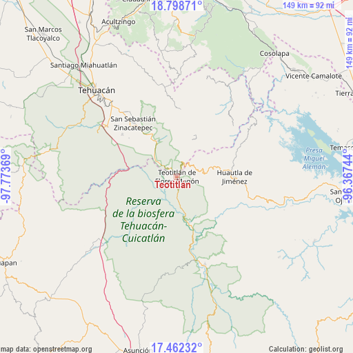
Teotitlán GPS coordinates[2]
18° 7' 54.444" North, 97° 4' 14.016" West
| Map corner | latitude | longitude |
|---|---|---|
| Upper-left | 18.79871°, | -97.77369° |
| Center: | 18.13179°, | -97.07056° |
| Lower-right: | 17.46232°, | -96.36744° |
| Map W x H: | 148.6×148.6 km | = 92.3×92.3mi |
| max Lat: | 32.7° ⇑77.2% North |
| Teotitlán: | 18.13179° |
| min Lat: | ⇓22.8% South 14.53588° |
| min Long | Teotitlán | max Long |
| -117.105° | -97.07056° | -86.73105° |
| W 74%⇐ | ⇒26% E |
Elevation
Elevation of Teotitlán is 1042 m = 3419 ft, and this is 211.7 m = 695 ft below average elevation for this country.
| Max E: |
3497 m = 11473 ft | 59.2% |
| Avg. | 1253.7 m = 4113 ft | |
| Teotitlán | 1042 m = 3419 ft | |
Min E: |
-1 m = -3 ft | 40.8% |
See also: Mexico elevation on elevation.city.
Geographical zone
Teotitlán is located in North Torrid zone (between Equator and Tropic of Cancer). Distance of this Northern Tropic circle is 589.9 km =366.5 mi to North.| Distance of | km | miles | from Teotitlán |
|---|---|---|---|
| North Pole | 7991 | 4965.4 | to North |
| Arctic Circle | 5385.1 | 3346.1 | to North |
| Tropic Cancer | 589.9 | 366.5 | to North |
| Equator | 2016.1 | 1252.7 | to South |


Nearby cities:
15 places around Teotitlán: (largest is in red/bold)
• Chichiltepec
12.2 km =7.6 mi,  350°
350°
• El Duraznillo
9.4 km =5.8 mi,  103°
103°
• Ignacio Mejía
6 km =3.7 mi,  231°
231°
• Los Frailes
13.3 km =8.3 mi, 103°
• Nanahuatípam
5.8 km =3.6 mi,  272°
272°
• San Francisco Huehuetlán
14.8 km =9.2 mi,  60°
60°
• San José Tilapa
4.8 km =3 mi,  317°
317°
• San Juan de los Cues
9.5 km =5.9 mi,  173°
173°
• Santa María Teopoxco
12.8 km =8 mi,  72°
72°
• Santiago Texcalcingo
13.7 km =8.5 mi,  51°
51°
• Tecuanapam
12.1 km =7.5 mi, 73°
• Tepantitlán
12.3 km =7.6 mi, 47°
• Tepoxtla
14.8 km =9.2 mi,  33°
33°
• Toxpalan
3.6 km =2.2 mi,  159°
159°
• Villa Nueva
10.8 km =6.7 mi, 61°
Sources, notices
• [Note1] Compared only with cities in Mexico existing in our database
• [Src1] Map data: © OpenStreetMap contributors (CC-BY-SA)
• [Src2] Other city data from geonames.org with taken over terms of usage.
• [Src3] Geographical zone / Annual Mean Temperature by Robert A. Rohde @ Wikipedia
