Nanacamila geodata
Nanacamila (Puebla) is a populated place; located in Mexico in America/Mexico_City (GMT-6) time zone. With population of 662 people, there are 13120 cities with bigger population in this country. Compared to other cities in Mexico, 57.2% of cities are located further ↓South; 62.3% of cities are located further ←West and 86.6% of cities have lower elevation than Nanacamila. Note1


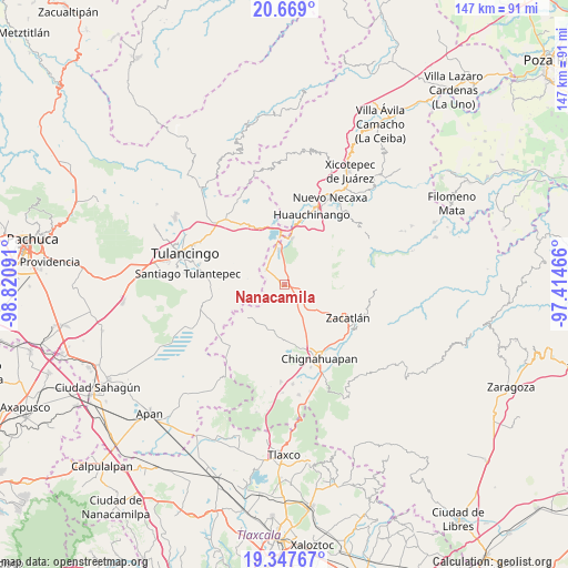
Nanacamila GPS coordinates[2]
20° 0' 34.992" North, 98° 7' 4.008" West
| Map corner | latitude | longitude |
|---|---|---|
| Upper-left | 20.669°, | -98.82091° |
| Center: | 20.00972°, | -98.11778° |
| Lower-right: | 19.34767°, | -97.41466° |
| Map W x H: | 146.9×146.9 km | = 91.3×91.3mi |
| max Lat: | 32.7° ⇑42.8% North |
| Nanacamila: | 20.00972° |
| min Lat: | ⇓57.2% South 14.53588° |
| min Long | Nanacamila | max Long |
| -117.105° | -98.11778° | -86.73105° |
| W 62.3%⇐ | ⇒37.7% E |
Elevation
Elevation of Nanacamila is 2299 m = 7543 ft, and this is 1045.3 m = 3429 ft above average elevation for this country.
| Max E: |
3497 m = 11473 ft | 13.4% |
| Nanacamila | 2299 m 7543 ft | |
| Avg. | 1253.7 m = 4113 ft | |
Min E: |
-1 m = -3 ft | 86.6% |
See also: Mexico elevation on elevation.city.
Geographical zone
Nanacamila is located in North Torrid zone (between Equator and Tropic of Cancer). Distance of this Northern Tropic circle is 381 km =236.7 mi to North.| Distance of | km | miles | from Nanacamila |
|---|---|---|---|
| North Pole | 7782.2 | 4835.6 | to North |
| Arctic Circle | 5176.3 | 3216.4 | to North |
| Tropic Cancer | 381 | 236.7 | to North |
| Equator | 2224.9 | 1382.5 | to South |


Nearby cities:
15 places around Nanacamila: (largest is in red/bold)
• Ahuazotepec
6.2 km =3.9 mi,  309°
309°
• Atotonilco
1.9 km =1.2 mi,  233°
233°
• Beristain
9.5 km =5.9 mi,  350°
350°
• Camotepec
6.6 km =4.1 mi,  51°
51°
• La Estación de Ahuazotepec
5.7 km =3.5 mi,  322°
322°
• Laguna Seca
3.5 km =2.2 mi, 347°
• Las Lajas
4.8 km =3 mi,  105°
105°
• Las Lajas Primera Sección
2.9 km =1.8 mi,  93°
93°
• Las Puentes
8.1 km =5 mi,  298°
298°
• Matlahuacala
11.4 km =7.1 mi,  128°
128°
• Mesa de Capulines
11.4 km =7.1 mi,  359°
359°
• Metepec
6.8 km =4.2 mi, 114°
• Pueblo Nuevo (Peñuelas)
6.1 km =3.8 mi,  173°
173°
• San Francisco Terrerillos
12.1 km =7.5 mi,  203°
203°
• Teopancingo
10.7 km =6.6 mi,  28°
28°
Sources, notices
• [Note1] Compared only with cities in Mexico existing in our database
• [Src1] Map data: © OpenStreetMap contributors (CC-BY-SA)
• [Src2] Other city data from geonames.org with taken over terms of usage.
• [Src3] Geographical zone / Annual Mean Temperature by Robert A. Rohde @ Wikipedia
