El Clavo geodata
El Clavo (Chiapas) is a populated place; located in Mexico in America/Mexico_City (GMT-6) time zone. With population of 775 people, there are 11274 cities with bigger population in this country. Compared to other cities in Mexico, 84.4% of cities are located further ↑North; 96.1% of cities are located further ←West and 77.2% of cities have higher elevation than El Clavo. Note1


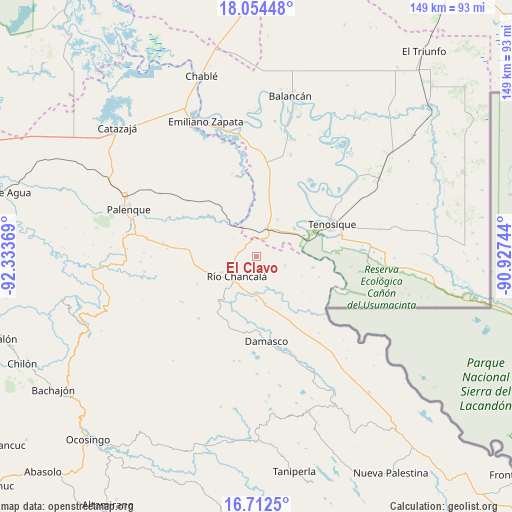
El Clavo GPS coordinates[2]
17° 23' 4.992" North, 91° 37' 50.016" West
| Map corner | latitude | longitude |
|---|---|---|
| Upper-left | 18.05448°, | -92.33369° |
| Center: | 17.38472°, | -91.63056° |
| Lower-right: | 16.7125°, | -90.92744° |
| Map W x H: | 149.2×149.2 km | = 92.7×92.7mi |
| max Lat: | 32.7° ⇑84.4% North |
| El Clavo: | 17.38472° |
| min Lat: | ⇓15.6% South 14.53588° |
| min Long | El Clavo | max Long |
| -117.105° | -91.63056° | -86.73105° |
| W 96.1%⇐ | ⇒3.9% E |
Elevation
Elevation of El Clavo is 148 m = 486 ft, and this is 1105.7 m = 3628 ft below average elevation for this country.
| Max E: |
3497 m = 11473 ft | 77.2% |
| Avg. | 1253.7 m = 4113 ft | |
| El Clavo | 148 m = 486 ft | |
Min E: |
-1 m = -3 ft | 22.8% |
See also: Mexico elevation on elevation.city.
Geographical zone
El Clavo is located in North Torrid zone (between Equator and Tropic of Cancer). Distance of this Northern Tropic circle is 672.9 km =418.1 mi to North.| Distance of | km | miles | from El Clavo |
|---|---|---|---|
| North Pole | 8074.1 | 5017 | to North |
| Arctic Circle | 5468.2 | 3397.8 | to North |
| Tropic Cancer | 672.9 | 418.1 | to North |
| Equator | 1933 | 1201.1 | to South |


Nearby cities:
15 places around El Clavo: (largest is in red/bold)
• Arena de Hidalgo
9.3 km =5.8 mi,  28°
28°
• Cristóbal Colón
21.4 km =13.3 mi,  179°
179°
• El Desierto
8.4 km =5.2 mi,  310°
310°
• El Edén
14.5 km =9 mi,  148°
148°
• Hermenegildo Galeana
18.9 km =11.7 mi,  245°
245°
• La Cascada
18.5 km =11.5 mi,  265°
265°
• La Isla
18.7 km =11.6 mi,  55°
55°
• La Reforma de Ocampo
10.4 km =6.5 mi,  220°
220°
• Lázaro Cárdenas
8.8 km =5.5 mi,  107°
107°
• Nueva Samaria
21 km =13 mi,  174°
174°
• Nuevo San Joaquín
18 km =11.2 mi,  228°
228°
• Río Chancalá
8 km =5 mi, 225°
• San José Pathuitz
22.1 km =13.7 mi,  188°
188°
• San Juan Chancalaíto
11.2 km =7 mi, 245°
• San Martín Chamizal
13.5 km =8.4 mi, 169°
Sources, notices
• [Note1] Compared only with cities in Mexico existing in our database
• [Src1] Map data: © OpenStreetMap contributors (CC-BY-SA)
• [Src2] Other city data from geonames.org with taken over terms of usage.
• [Src3] Geographical zone / Annual Mean Temperature by Robert A. Rohde @ Wikipedia
