Ignacio Allende geodata
Ignacio Allende (Chiapas) is a populated place; located in Mexico in America/Mexico_City (GMT-6) time zone. With population of 855 people, there are 10232 cities with bigger population in this country. Compared to other cities in Mexico, 85.9% of cities are located further ↑North; 94.5% of cities are located further ←West and 69.2% of cities have higher elevation than Ignacio Allende. Note1


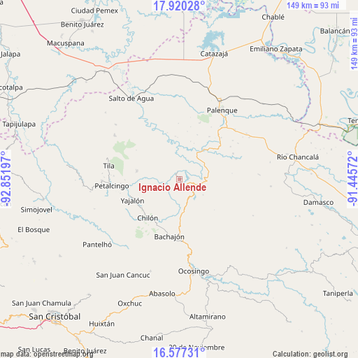
Ignacio Allende GPS coordinates[2]
17° 15' 0.072" North, 92° 8' 55.824" West
| Map corner | latitude | longitude |
|---|---|---|
| Upper-left | 17.92028°, | -92.85197° |
| Center: | 17.25002°, | -92.14884° |
| Lower-right: | 16.57731°, | -91.44572° |
| Map W x H: | 149.3×149.3 km | = 92.8×92.8mi |
| max Lat: | 32.7° ⇑85.9% North |
| Ignacio Allende: | 17.25002° |
| min Lat: | ⇓14.1% South 14.53588° |
| min Long | Ignacio Allende | max Long |
| -117.105° | -92.14884° | -86.73105° |
| W 94.5%⇐ | ⇒5.5% E |
Elevation
Elevation of Ignacio Allende is 458 m = 1503 ft, and this is 795.7 m = 2611 ft below average elevation for this country.
| Max E: |
3497 m = 11473 ft | 69.2% |
| Avg. | 1253.7 m = 4113 ft | |
| Ignacio Allende | 458 m = 1503 ft | |
Min E: |
-1 m = -3 ft | 30.8% |
See also: Mexico elevation on elevation.city.
Geographical zone
Ignacio Allende is located in North Torrid zone (between Equator and Tropic of Cancer). Distance of this Northern Tropic circle is 687.9 km =427.4 mi to North.| Distance of | km | miles | from Ignacio Allende |
|---|---|---|---|
| North Pole | 8089 | 5026.3 | to North |
| Arctic Circle | 5483.2 | 3407.1 | to North |
| Tropic Cancer | 687.9 | 427.4 | to North |
| Equator | 1918 | 1191.8 | to South |


Nearby cities:
15 places around Ignacio Allende: (largest is in red/bold)
• Amado Nervo
10.5 km =6.5 mi,  258°
258°
• Benito Juárez
11.4 km =7.1 mi,  274°
274°
• Cacahuatal
11.5 km =7.1 mi,  314°
314°
• Centro Chich
8.9 km =5.5 mi,  182°
182°
• Chabán
4.8 km =3 mi,  143°
143°
• Cuctiepa
7 km =4.3 mi,  334°
334°
• José María Morelos y Pavón
7.5 km =4.7 mi,  291°
291°
• La Esperanza Mórrizon
5.7 km =3.5 mi, 274°
• Pactiún
8.6 km =5.3 mi,  281°
281°
• Patatehel
8.9 km =5.5 mi,  192°
192°
• Patelná
2.9 km =1.8 mi,  246°
246°
• Río Tulija
12.1 km =7.5 mi,  64°
64°
• Suluphuitz
8.9 km =5.5 mi,  232°
232°
• Venustiano Carranza
6.4 km =4 mi,  336°
336°
• Xaxajatic
11.2 km =7 mi, 184°
Sources, notices
• [Note1] Compared only with cities in Mexico existing in our database
• [Src1] Map data: © OpenStreetMap contributors (CC-BY-SA)
• [Src2] Other city data from geonames.org with taken over terms of usage.
• [Src3] Geographical zone / Annual Mean Temperature by Robert A. Rohde @ Wikipedia
