José María Morelos y Pavón geodata
José María Morelos y Pavón (Chiapas) is a populated place; located in Mexico in America/Mexico_City (GMT-6) time zone. With population of 636 people, there are 13615 cities with bigger population in this country. Compared to other cities in Mexico, 85.6% of cities are located further ↑North; 94% of cities are located further ←West and 64.6% of cities have higher elevation than José María Morelos y Pavón. Note1
Current local time in José María Morelos y Pavón:
12:57 AM, WednesdayDifference from your time zone: hours


José María Morelos y Pavón GPS coordinates[2]
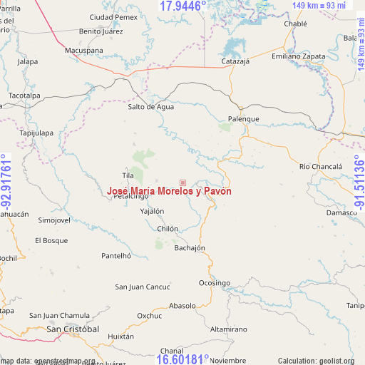
17° 16' 27.948" North, 92° 12' 52.128" West
| Map corner | latitude | longitude |
|---|---|---|
| Upper-left | 17.9446°, | -92.91761° |
| Center: | 17.27443°, | -92.21448° |
| Lower-right: | 16.60181°, | -91.51136° |
| Map W x H: | 149.3×149.3 km | = 92.8×92.8mi |
| max Lat: | 32.7° ⇑85.6% North |
| José María Morelos y Pavón: | 17.27443° |
| min Lat: | ⇓14.4% South 14.53588° |
| min Long | José María Mo | max Long |
| -117.105° | -92.21448° | -86.73105° |
| W 94%⇐ | ⇒6% E |
Elevation
Elevation of José María Morelos y Pavón is 709 m = 2326 ft, and this is 544.7 m = 1787 ft below average elevation for this country.
| Max E: |
3497 m = 11473 ft | 64.6% |
| Avg. | 1253.7 m = 4113 ft | |
| José María Morelos y Pavón | 709 m = 2326 ft | |
Min E: |
-1 m = -3 ft | 35.4% |
See also: Mexico elevation on elevation.city.
Geographical zone
José María Morelos y Pavón is located in North Torrid zone (between Equator and Tropic of Cancer). Distance of this Northern Tropic circle is 685.2 km =425.8 mi to North.| Distance of | km | miles | from José María Morelos y Pavón |
|---|---|---|---|
| North Pole | 8086.3 | 5024.6 | to North |
| Arctic Circle | 5480.4 | 3405.4 | to North |
| Tropic Cancer | 685.2 | 425.8 | to North |
| Equator | 1920.7 | 1193.5 | to South |


Nearby cities:
15 places around José María Morelos y Pavón: (largest is in red/bold)
• Amado Nervo
5.9 km =3.7 mi,  214°
214°
• Benito Juárez
4.8 km =3 mi,  247°
247°
• Cacahuatal
5.5 km =3.4 mi,  347°
347°
• Chabán
11.8 km =7.3 mi,  123°
123°
• Chuchucruz Primera Sección
6.7 km =4.2 mi,  299°
299°
• Cuctiepa
5.4 km =3.4 mi,  47°
47°
• Emiliano Zapata
10.7 km =6.6 mi,  311°
311°
• Ignacio Allende
7.5 km =4.7 mi,  111°
111°
• Joljamil
11.5 km =7.1 mi,  263°
263°
• La Esperanza Mórrizon
2.6 km =1.6 mi,  151°
151°
• Pactiún
1.8 km =1.1 mi,  234°
234°
• Patelná
5.8 km =3.6 mi,  132°
132°
• Suluphuitz
8.2 km =5.1 mi,  180°
180°
• Tumbala
10.9 km =6.8 mi,  271°
271°
• Venustiano Carranza
5.4 km =3.4 mi, 54°
Sources, notices
• [Note1] Compared only with cities in Mexico existing in our database
• [Src1] Map data: © OpenStreetMap contributors (CC-BY-SA)
• [Src2] Other city data from geonames.org with taken over terms of usage.
• [Src3] Geographical zone / Annual Mean Temperature by Robert A. Rohde @ Wikipedia
