Amado Nervo geodata
Amado Nervo (Chiapas) is a populated place; located in Mexico in America/Mexico_City (GMT-6) time zone. With population of 1,362 people, there are 6375 cities with bigger population in this country. Compared to other cities in Mexico, 86.1% of cities are located further ↑North; 93.8% of cities are located further ←West and 61.4% of cities have higher elevation than Amado Nervo. Note1


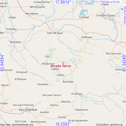
Amado Nervo GPS coordinates[2]
17° 13' 51.852" North, 92° 14' 44.916" West
| Map corner | latitude | longitude |
|---|---|---|
| Upper-left | 17.9014°, | -92.94894° |
| Center: | 17.23107°, | -92.24581° |
| Lower-right: | 16.5583°, | -91.54269° |
| Map W x H: | 149.3×149.3 km | = 92.8×92.8mi |
| max Lat: | 32.7° ⇑86.1% North |
| Amado Nervo: | 17.23107° |
| min Lat: | ⇓13.9% South 14.53588° |
| min Long | Amado Nervo | max Long |
| -117.105° | -92.24581° | -86.73105° |
| W 93.8%⇐ | ⇒6.2% E |
Elevation
Elevation of Amado Nervo is 911 m = 2989 ft, and this is 342.7 m = 1124 ft below average elevation for this country.
| Max E: |
3497 m = 11473 ft | 61.4% |
| Avg. | 1253.7 m = 4113 ft | |
| Amado Nervo | 911 m = 2989 ft | |
Min E: |
-1 m = -3 ft | 38.6% |
See also: Mexico elevation on elevation.city.
Geographical zone
Amado Nervo is located in North Torrid zone (between Equator and Tropic of Cancer). Distance of this Northern Tropic circle is 690 km =428.7 mi to North.| Distance of | km | miles | from Amado Nervo |
|---|---|---|---|
| North Pole | 8091.1 | 5027.6 | to North |
| Arctic Circle | 5485.3 | 3408.4 | to North |
| Tropic Cancer | 690 | 428.7 | to North |
| Equator | 1915.9 | 1190.5 | to South |


Nearby cities:
15 places around Amado Nervo: (largest is in red/bold)
• Benito Juárez
3.2 km =2 mi,  339°
339°
• Cacahuatal
10.4 km =6.5 mi,  11°
11°
• Chuchucruz Primera Sección
8.5 km =5.3 mi, 342°
• Hidalgo Joshil
10.8 km =6.7 mi,  267°
267°
• Ignacio Allende
10.5 km =6.5 mi,  78°
78°
• Joljamil
8.8 km =5.5 mi,  292°
292°
• José María Morelos y Pavón
5.9 km =3.7 mi,  34°
34°
• La Esperanza Mórrizon
5.2 km =3.2 mi,  61°
61°
• Pactiún
4.2 km =2.6 mi, 26°
• Patatehel
10.6 km =6.6 mi,  128°
128°
• Patelná
7.7 km =4.8 mi, 83°
• Suluphuitz
4.7 km =2.9 mi,  135°
135°
• Tumbala
9.2 km =5.7 mi,  304°
304°
• Tzasibiltic
10.4 km =6.5 mi,  206°
206°
• Venustiano Carranza
11 km =6.8 mi,  44°
44°
Sources, notices
• [Note1] Compared only with cities in Mexico existing in our database
• [Src1] Map data: © OpenStreetMap contributors (CC-BY-SA)
• [Src2] Other city data from geonames.org with taken over terms of usage.
• [Src3] Geographical zone / Annual Mean Temperature by Robert A. Rohde @ Wikipedia
