Patelná geodata
Patelná (Chiapas) is a populated place; located in Mexico in America/Mexico_City (GMT-6) time zone. With population of 597 people, there are 14400 cities with bigger population in this country. Compared to other cities in Mexico, 86.1% of cities are located further ↑North; 94.3% of cities are located further ←West and 62.3% of cities have higher elevation than Patelná. Note1


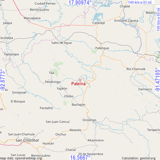
Patelná GPS coordinates[2]
17° 14' 21.984" North, 92° 10' 27.012" West
| Map corner | latitude | longitude |
|---|---|---|
| Upper-left | 17.90974°, | -92.8773° |
| Center: | 17.23944°, | -92.17417° |
| Lower-right: | 16.5667°, | -91.47105° |
| Map W x H: | 149.3×149.3 km | = 92.8×92.8mi |
| max Lat: | 32.7° ⇑86.1% North |
| Patelná: | 17.23944° |
| min Lat: | ⇓13.9% South 14.53588° |
| min Long | Patelná | max Long |
| -117.105° | -92.17417° | -86.73105° |
| W 94.3%⇐ | ⇒5.7% E |
Elevation
Elevation of Patelná is 868 m = 2848 ft, and this is 385.7 m = 1265 ft below average elevation for this country.
| Max E: |
3497 m = 11473 ft | 62.3% |
| Avg. | 1253.7 m = 4113 ft | |
| Patelná | 868 m = 2848 ft | |
Min E: |
-1 m = -3 ft | 37.7% |
See also: Mexico elevation on elevation.city.
Geographical zone
Patelná is located in North Torrid zone (between Equator and Tropic of Cancer). Distance of this Northern Tropic circle is 689.1 km =428.2 mi to North.| Distance of | km | miles | from Patelná |
|---|---|---|---|
| North Pole | 8090.2 | 5027 | to North |
| Arctic Circle | 5484.3 | 3407.8 | to North |
| Tropic Cancer | 689.1 | 428.2 | to North |
| Equator | 1916.8 | 1191 | to South |


Nearby cities:
15 places around Patelná: (largest is in red/bold)
• Amado Nervo
7.7 km =4.8 mi,  263°
263°
• Benito Juárez
8.9 km =5.5 mi,  283°
283°
• Cacahuatal
10.7 km =6.6 mi,  329°
329°
• Centro Chich
8 km =5 mi,  163°
163°
• Chabán
6.1 km =3.8 mi,  115°
115°
• Chuchucruz Primera Sección
12.4 km =7.7 mi,  305°
305°
• Cuctiepa
7.5 km =4.7 mi,  357°
357°
• Ignacio Allende
2.9 km =1.8 mi,  66°
66°
• José María Morelos y Pavón
5.8 km =3.6 mi, 312°
• La Esperanza Mórrizon
3.4 km =2.1 mi,  297°
297°
• Pactiún
6.4 km =4 mi, 296°
• Patatehel
7.5 km =4.7 mi,  174°
174°
• Suluphuitz
6.1 km =3.8 mi,  225°
225°
• Venustiano Carranza
7 km =4.3 mi,  0°
0°
• Xaxajatic
10.1 km =6.3 mi, 169°
Sources, notices
• [Note1] Compared only with cities in Mexico existing in our database
• [Src1] Map data: © OpenStreetMap contributors (CC-BY-SA)
• [Src2] Other city data from geonames.org with taken over terms of usage.
• [Src3] Geographical zone / Annual Mean Temperature by Robert A. Rohde @ Wikipedia
