La Esperanza MĂłrrizon geodata
La Esperanza MĂłrrizon (Chiapas) is a populated place; located in Mexico in America/Mexico_City (GMT-6) time zone. With population of 614 people, there are 14035 cities with bigger population in this country. Compared to other cities in Mexico, 85.8% of cities are located further ↑North; 94.1% of cities are located further ←West and 62.8% of cities have higher elevation than La Esperanza MĂłrrizon. Note1
Current local time in La Esperanza MĂłrrizon:
06:56 AM, WednesdayDifference from your time zone: hours


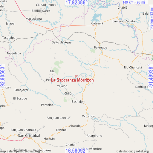
La Esperanza MĂłrrizon GPS coordinates[2]
17° 15' 12.996" North, 92° 12' 9" West
| Map corner | latitude | longitude |
|---|---|---|
| Upper-left | 17.92386°, | -92.90563° |
| Center: | 17.25361°, | -92.2025° |
| Lower-right: | 16.58092°, | -91.49938° |
| Map W x H: | 149.3×149.3 km | = 92.8Ă—92.8mi |
| max Lat: | 32.7° ⇑85.8% North |
| La Esperanza MĂłrrizon: | 17.25361° |
| min Lat: | ⇓14.2% South 14.53588° |
| min Long | La Esperanza MĂ | max Long |
| -117.105° | -92.2025° | -86.73105° |
| W 94.1%⇐ | ⇒5.9% E |
Elevation
Elevation of La Esperanza MĂłrrizon is 835 m = 2740 ft, and this is 418.7 m = 1374 ft below average elevation for this country.
| Max E: |
3497 m = 11473 ft | 62.8% |
| Avg. | 1253.7 m = 4113 ft | |
| La Esperanza MĂłrrizon | 835 m = 2740 ft | |
Min E: |
-1 m = -3 ft | 37.2% |
See also: Mexico elevation on elevation.city.
Geographical zone
La Esperanza MĂłrrizon is located in North Torrid zone (between Equator and Tropic of Cancer). Distance of this Northern Tropic circle is 687.5 km =427.2 mi to North.| Distance of | km | miles | from La Esperanza MĂłrrizon |
|---|---|---|---|
| North Pole | 8088.6 | 5026 | to North |
| Arctic Circle | 5482.8 | 3406.9 | to North |
| Tropic Cancer | 687.5 | 427.2 | to North |
| Equator | 1918.4 | 1192 | to South |


Nearby cities:
15 places around La Esperanza MĂłrrizon: (largest is in red/bold)
• Amado Nervo
5.2 km =3.2 mi,  241°
241°
• Benito Juárez
5.7 km =3.5 mi,  274°
274°
• Cacahuatal
8 km =5 mi,  342°
342°
• Centro Chich
10.7 km =6.6 mi,  150°
150°
• Chabán
9.5 km =5.9 mi,  116°
116°
• Chuchucruz Primera SecciĂłn
9.1 km =5.7 mi,  307°
307°
• Cuctiepa
6.5 km =4 mi,  24°
24°
• Ignacio Allende
5.7 km =3.5 mi,  94°
94°
• JosĂ© MarĂa Morelos y PavĂłn
2.6 km =1.6 mi,  331°
331°
• PactiĂşn
3 km =1.9 mi,  295°
295°
• Patatehel
9.8 km =6.1 mi,  157°
157°
• Patelná
3.4 km =2.1 mi, 117°
• Suluphuitz
6 km =3.7 mi,  192°
192°
• Tumbala
12.4 km =7.7 mi,  282°
282°
• Venustiano Carranza
6.2 km =3.9 mi,  29°
29°
Sources, notices
• [Note1] Compared only with cities in Mexico existing in our database
• [Src1] Map data: © OpenStreetMap contributors (CC-BY-SA)
• [Src2] Other city data from geonames.org with taken over terms of usage.
• [Src3] Geographical zone / Annual Mean Temperature by Robert A. Rohde @ Wikipedia
