El Azufre geodata
El Azufre (Chiapas) is a populated place; located in Mexico in America/Mexico_City (GMT-6) time zone. With population of 868 people, there are 10069 cities with bigger population in this country. Compared to other cities in Mexico, 86.5% of cities are located further ↑North; 90.8% of cities are located further ←West and 64.1% of cities have higher elevation than El Azufre. Note1


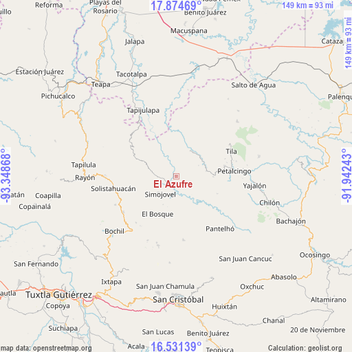
El Azufre GPS coordinates[2]
17° 12' 15.336" North, 92° 38' 43.98" West
| Map corner | latitude | longitude |
|---|---|---|
| Upper-left | 17.87469°, | -93.34868° |
| Center: | 17.20426°, | -92.64555° |
| Lower-right: | 16.53139°, | -91.94243° |
| Map W x H: | 149.4×149.4 km | = 92.8×92.8mi |
| max Lat: | 32.7° ⇑86.5% North |
| El Azufre: | 17.20426° |
| min Lat: | ⇓13.5% South 14.53588° |
| min Long | El Azufre | max Long |
| -117.105° | -92.64555° | -86.73105° |
| W 90.8%⇐ | ⇒9.2% E |
Elevation
Elevation of El Azufre is 746 m = 2448 ft, and this is 507.7 m = 1666 ft below average elevation for this country.
| Max E: |
3497 m = 11473 ft | 64.1% |
| Avg. | 1253.7 m = 4113 ft | |
| El Azufre | 746 m = 2448 ft | |
Min E: |
-1 m = -3 ft | 35.9% |
See also: Mexico elevation on elevation.city.
Geographical zone
El Azufre is located in North Torrid zone (between Equator and Tropic of Cancer). Distance of this Northern Tropic circle is 693 km =430.6 mi to North.| Distance of | km | miles | from El Azufre |
|---|---|---|---|
| North Pole | 8094.1 | 5029.4 | to North |
| Arctic Circle | 5488.2 | 3410.2 | to North |
| Tropic Cancer | 693 | 430.6 | to North |
| Equator | 1912.9 | 1188.6 | to South |


Nearby cities:
15 places around El Azufre: (largest is in red/bold)
• Asunción Huitiupan
8.1 km =5 mi,  71°
71°
• El Calvario
9.5 km =5.9 mi,  81°
81°
• El Jardín
6.5 km =4 mi,  130°
130°
• El Ocotal
11.3 km =7 mi,  268°
268°
• El Paraíso
10.5 km =6.5 mi,  63°
63°
• Emiliano Zapata
5.6 km =3.5 mi,  7°
7°
• Huitiupán
5.6 km =3.5 mi,  230°
230°
• José María Morelos y Pavón
7.3 km =4.5 mi,  304°
304°
• Los Naranjos
7.2 km =4.5 mi,  22°
22°
• Lázaro Cárdenas
5.8 km =3.6 mi, 69°
• Majastic
9.6 km =6 mi, 10°
• Natividad Pechuag
11.1 km =6.9 mi,  164°
164°
• Ramos Cubilete
7.2 km =4.5 mi,  327°
327°
• San Antonio Nuevo León
11.2 km =7 mi,  117°
117°
• Simojovel de Allende
10.2 km =6.3 mi, 225°
Sources, notices
• [Note1] Compared only with cities in Mexico existing in our database
• [Src1] Map data: © OpenStreetMap contributors (CC-BY-SA)
• [Src2] Other city data from geonames.org with taken over terms of usage.
• [Src3] Geographical zone / Annual Mean Temperature by Robert A. Rohde @ Wikipedia
