Santo Tomás Atzingo geodata
Santo Tomás Atzingo (State of Mexico) is a populated place; located in Mexico in America/Mexico_City (GMT-6) time zone. With population of 2,151 people, there are 4082 cities with bigger population in this country. Compared to other cities in Mexico, 61.8% of cities are located further ↑North; 53.9% of cities are located further ←West and 92.2% of cities have lower elevation than Santo Tomás Atzingo. Note1


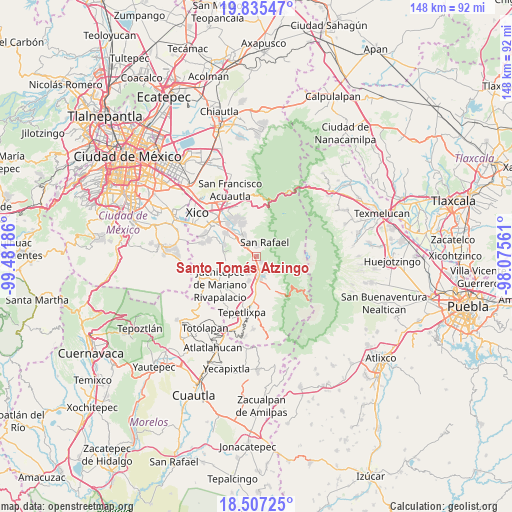
Santo Tomás Atzingo GPS coordinates[2]
19° 10' 21.72" North, 98° 46' 43.428" West
| Map corner | latitude | longitude |
|---|---|---|
| Upper-left | 19.83547°, | -99.48186° |
| Center: | 19.1727°, | -98.77873° |
| Lower-right: | 18.50725°, | -98.07561° |
| Map W x H: | 147.7×147.7 km | = 91.8×91.8mi |
| max Lat: | 32.7° ⇑61.8% North |
| Santo Tomás Atzingo: | 19.1727° |
| min Lat: | ⇓38.2% South 14.53588° |
| min Long | Santo Tomás At | max Long |
| -117.105° | -98.77873° | -86.73105° |
| W 53.9%⇐ | ⇒46.1% E |
Elevation
Elevation of Santo Tomás Atzingo is 2491 m = 8173 ft, and this is 1237.3 m = 4059 ft above average elevation for this country.
| Max E: |
3497 m = 11473 ft | 7.8% |
| Santo Tomás Atzingo | 2491 m 8173 ft | |
| Avg. | 1253.7 m = 4113 ft | |
Min E: |
-1 m = -3 ft | 92.2% |
See also: Mexico elevation on elevation.city.
Geographical zone
Santo Tomás Atzingo is located in North Torrid zone (between Equator and Tropic of Cancer). Distance of this Northern Tropic circle is 474.1 km =294.6 mi to North.| Distance of | km | miles | from Santo Tomás Atzingo |
|---|---|---|---|
| North Pole | 7875.3 | 4893.5 | to North |
| Arctic Circle | 5269.4 | 3274.3 | to North |
| Tropic Cancer | 474.1 | 294.6 | to North |
| Equator | 2131.8 | 1324.6 | to South |


Nearby cities:
15 places around Santo Tomás Atzingo: (largest is in red/bold)
• Amecameca
5.6 km =3.5 mi,  166°
166°
• Ayapango
5.6 km =3.5 mi,  203°
203°
• La Colonia
3.3 km =2.1 mi,  194°
194°
• Miraflores
6.3 km =3.9 mi,  331°
331°
• Pahuacán
7.8 km =4.8 mi, 201°
• Poxtla
4.3 km =2.7 mi,  207°
207°
• San Antonio Tlaltecahuacán
1.9 km =1.2 mi,  147°
147°
• San Diego Chalcatepehuacán
5.3 km =3.3 mi,  180°
180°
• San Lorenzo Tlalmimilolpan
6 km =3.7 mi, 333°
• San Rafael
4.7 km =2.9 mi,  29°
29°
• Santa Isabel Chalma
2.2 km =1.4 mi,  140°
140°
• Santiago Cuautenco
4.3 km =2.7 mi,  129°
129°
• Tlalmanalco
4.3 km =2.7 mi, 326°
• Tlamapa
7 km =4.3 mi,  239°
239°
• Zentlalpan
2.6 km =1.6 mi, 194°
Sources, notices
• [Note1] Compared only with cities in Mexico existing in our database
• [Src1] Map data: © OpenStreetMap contributors (CC-BY-SA)
• [Src2] Other city data from geonames.org with taken over terms of usage.
• [Src3] Geographical zone / Annual Mean Temperature by Robert A. Rohde @ Wikipedia
