Tlamapa geodata
Tlamapa (State of Mexico) is a populated place; located in Mexico in America/Mexico_City (GMT-6) time zone. With population of 512 people, there are 16417 cities with bigger population in this country. Compared to other cities in Mexico, 62.3% of cities are located further ↑North; 53.1% of cities are located further ←West and 90.8% of cities have lower elevation than Tlamapa. Note1


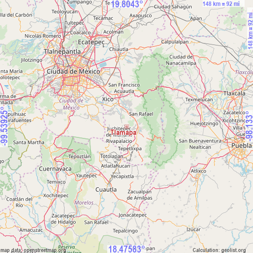
Tlamapa GPS coordinates[2]
19° 8' 29.04" North, 98° 50' 10.032" West
| Map corner | latitude | longitude |
|---|---|---|
| Upper-left | 19.8043°, | -99.53925° |
| Center: | 19.1414°, | -98.83612° |
| Lower-right: | 18.47583°, | -98.133° |
| Map W x H: | 147.7×147.7 km | = 91.8×91.8mi |
| max Lat: | 32.7° ⇑62.3% North |
| Tlamapa: | 19.1414° |
| min Lat: | ⇓37.7% South 14.53588° |
| min Long | Tlamapa | max Long |
| -117.105° | -98.83612° | -86.73105° |
| W 53.1%⇐ | ⇒46.9% E |
Elevation
Elevation of Tlamapa is 2432 m = 7979 ft, and this is 1178.3 m = 3866 ft above average elevation for this country.
| Max E: |
3497 m = 11473 ft | 9.2% |
| Tlamapa | 2432 m 7979 ft | |
| Avg. | 1253.7 m = 4113 ft | |
Min E: |
-1 m = -3 ft | 90.8% |
See also: Mexico elevation on elevation.city.
Geographical zone
Tlamapa is located in North Torrid zone (between Equator and Tropic of Cancer). Distance of this Northern Tropic circle is 477.6 km =296.8 mi to North.| Distance of | km | miles | from Tlamapa |
|---|---|---|---|
| North Pole | 7878.7 | 4895.6 | to North |
| Arctic Circle | 5272.8 | 3276.4 | to North |
| Tropic Cancer | 477.6 | 296.8 | to North |
| Equator | 2128.3 | 1322.5 | to South |


Nearby cities:
15 places around Tlamapa: (largest is in red/bold)
• Ayapango
4.1 km =2.5 mi,  112°
112°
• El Cabi
5.7 km =3.5 mi,  341°
341°
• Juchitepec
6.4 km =4 mi,  224°
224°
• La Colonia
5.2 km =3.2 mi,  86°
86°
• Mihuacan
4.6 km =2.9 mi,  141°
141°
• Pahuacán
5 km =3.1 mi, 140°
• Poxtla
4.1 km =2.5 mi,  95°
95°
• San Antonio Tlaltecahuacán
7.3 km =4.5 mi,  75°
75°
• San Diego Chalcatepehuacán
6.3 km =3.9 mi, 106°
• San Juan Coxtocan
1.2 km =0.7 mi,  258°
258°
• San Matías Cuijingo
6.5 km =4 mi,  195°
195°
• Santiago Tepopula
2.2 km =1.4 mi,  277°
277°
• Santo Tomás Atzingo
7 km =4.3 mi,  59°
59°
• Tenango del Aire
2.8 km =1.7 mi,  309°
309°
• Zentlalpan
5.5 km =3.4 mi, 79°
Sources, notices
• [Note1] Compared only with cities in Mexico existing in our database
• [Src1] Map data: © OpenStreetMap contributors (CC-BY-SA)
• [Src2] Other city data from geonames.org with taken over terms of usage.
• [Src3] Geographical zone / Annual Mean Temperature by Robert A. Rohde @ Wikipedia
