Juchitepec geodata
Juchitepec (State of Mexico) is a seat of a second-order administrative division; located in Mexico in America/Mexico_City (GMT-6) time zone. With population of 16,021 people, there are 600 cities with bigger population in this country. Compared to other cities in Mexico, 63.1% of cities are located further ↑North; 52.3% of cities are located further ←West and 93.1% of cities have lower elevation than Juchitepec. Note1


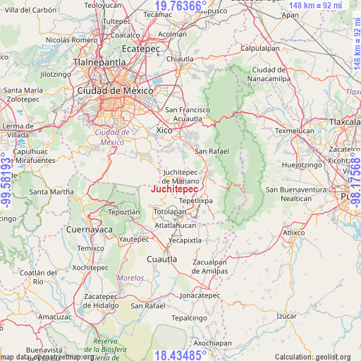
Juchitepec GPS coordinates[2]
19° 6' 2.124" North, 98° 52' 43.68" West
| Map corner | latitude | longitude |
|---|---|---|
| Upper-left | 19.76366°, | -99.58193° |
| Center: | 19.10059°, | -98.8788° |
| Lower-right: | 18.43485°, | -98.17568° |
| Map W x H: | 147.7×147.8 km | = 91.8×91.8mi |
| max Lat: | 32.7° ⇑63.1% North |
| Juchitepec: | 19.10059° |
| min Lat: | ⇓36.9% South 14.53588° |
| min Long | Juchitepec | max Long |
| -117.105° | -98.8788° | -86.73105° |
| W 52.3%⇐ | ⇒47.7% E |
Elevation
Elevation of Juchitepec is 2535 m = 8317 ft, and this is 1281.3 m = 4204 ft above average elevation for this country.
| Max E: |
3497 m = 11473 ft | 6.9% |
| Juchitepec | 2535 m 8317 ft | |
| Avg. | 1253.7 m = 4113 ft | |
Min E: |
-1 m = -3 ft | 93.1% |
See also: Mexico elevation on elevation.city.
Geographical zone
Juchitepec is located in North Torrid zone (between Equator and Tropic of Cancer). Distance of this Northern Tropic circle is 482.1 km =299.6 mi to North.| Distance of | km | miles | from Juchitepec |
|---|---|---|---|
| North Pole | 7883.3 | 4898.5 | to North |
| Arctic Circle | 5277.4 | 3279.2 | to North |
| Tropic Cancer | 482.1 | 299.6 | to North |
| Equator | 2123.8 | 1319.7 | to South |


Nearby cities:
15 places around Juchitepec: (largest is in red/bold)
• Ayapango
8.8 km =5.5 mi,  70°
70°
• Cuecuecuatitla
10.4 km =6.5 mi,  159°
159°
• El Cabi
10.3 km =6.4 mi,  14°
14°
• Felipe Neri (Cuatepec)
9.6 km =6 mi,  225°
225°
• Mihuacan
7.4 km =4.6 mi,  83°
83°
• Pahuacán
7.7 km =4.8 mi, 84°
• Poxtla
9.5 km =5.9 mi,  63°
63°
• San Juan Coxtocan
5.4 km =3.4 mi,  37°
37°
• San Mateo Tecalco
10.2 km =6.3 mi,  121°
121°
• San Matías Cuijingo
3.2 km =2 mi, 122°
• Santiago Tepopula
5.3 km =3.3 mi,  25°
25°
• Tenango del Aire
6.8 km =4.2 mi,  19°
19°
• Tepetlixpa
10 km =6.2 mi,  142°
142°
• Tlamapa
6.4 km =4 mi, 44°
• Zoyatzingo
10.1 km =6.3 mi,  96°
96°
Sources, notices
• [Note1] Compared only with cities in Mexico existing in our database
• [Src1] Map data: © OpenStreetMap contributors (CC-BY-SA)
• [Src2] Other city data from geonames.org with taken over terms of usage.
• [Src3] Geographical zone / Annual Mean Temperature by Robert A. Rohde @ Wikipedia
