San Gregorio geodata
San Gregorio (Hidalgo) is a populated place; located in Mexico in America/Mexico_City (GMT-6) time zone. With population of 1,351 people, there are 6439 cities with bigger population in this country. Compared to other cities in Mexico, 67.7% of cities are located further ↓South; 63.4% of cities are located further ←West and 62.6% of cities have higher elevation than San Gregorio. Note1


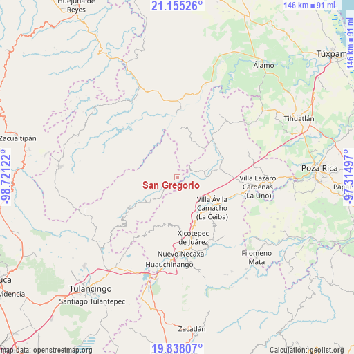
San Gregorio GPS coordinates[2]
20° 29' 53.088" North, 98° 1' 5.124" West
| Map corner | latitude | longitude |
|---|---|---|
| Upper-left | 21.15526°, | -98.72122° |
| Center: | 20.49808°, | -98.01809° |
| Lower-right: | 19.83807°, | -97.31497° |
| Map W x H: | 146.5×146.5 km | = 91×91mi |
| max Lat: | 32.7° ⇑32.3% North |
| San Gregorio: | 20.49808° |
| min Lat: | ⇓67.7% South 14.53588° |
| min Long | San Gregorio | max Long |
| -117.105° | -98.01809° | -86.73105° |
| W 63.4%⇐ | ⇒36.6% E |
Elevation
Elevation of San Gregorio is 845 m = 2772 ft, and this is 408.7 m = 1341 ft below average elevation for this country.
| Max E: |
3497 m = 11473 ft | 62.6% |
| Avg. | 1253.7 m = 4113 ft | |
| San Gregorio | 845 m = 2772 ft | |
Min E: |
-1 m = -3 ft | 37.4% |
See also: Mexico elevation on elevation.city.
Geographical zone
San Gregorio is located in North Torrid zone (between Equator and Tropic of Cancer). Distance of this Northern Tropic circle is 326.7 km =203 mi to North.| Distance of | km | miles | from San Gregorio |
|---|---|---|---|
| North Pole | 7727.9 | 4801.9 | to North |
| Arctic Circle | 5122 | 3182.7 | to North |
| Tropic Cancer | 326.7 | 203 | to North |
| Equator | 2279.2 | 1416.2 | to South |


Nearby cities:
15 places around San Gregorio: (largest is in red/bold)
• Acuautla
1.9 km =1.2 mi,  241°
241°
• Barrio Aztlán
7.9 km =4.9 mi, 242°
• El Pozo
5.1 km =3.2 mi,  68°
68°
• El Rincón
7.1 km =4.4 mi,  169°
169°
• Huehuetla
7.4 km =4.6 mi, 235°
• Ixtololoya
6.2 km =3.9 mi,  62°
62°
• Juntas Chicas
8.5 km =5.3 mi,  351°
351°
• Pantepec
8.7 km =5.4 mi, 72°
• San Ambrosio
3.4 km =2.1 mi, 354°
• San Andrés
8.1 km =5 mi,  273°
273°
• San Antonio el Grande
4.9 km =3 mi,  200°
200°
• San Esteban
6.8 km =4.2 mi,  319°
319°
• San Francisco
6.3 km =3.9 mi,  15°
15°
• Santa Inés
8.9 km =5.5 mi, 238°
• Tlaxco
8.4 km =5.2 mi,  187°
187°
Sources, notices
• [Note1] Compared only with cities in Mexico existing in our database
• [Src1] Map data: © OpenStreetMap contributors (CC-BY-SA)
• [Src2] Other city data from geonames.org with taken over terms of usage.
• [Src3] Geographical zone / Annual Mean Temperature by Robert A. Rohde @ Wikipedia
