Cuacuila geodata
Cuacuila (Puebla) is a populated place; located in Mexico in America/Mexico_City (GMT-6) time zone. With population of 3,050 people, there are 2953 cities with bigger population in this country. Compared to other cities in Mexico, 60.7% of cities are located further ↓South; 63.2% of cities are located further ←West and 51% of cities have lower elevation than Cuacuila. Note1


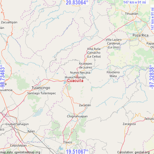
Cuacuila GPS coordinates[2]
20° 10' 19.38" North, 98° 1' 53.4" West
| Map corner | latitude | longitude |
|---|---|---|
| Upper-left | 20.83064°, | -98.73463° |
| Center: | 20.17205°, | -98.0315° |
| Lower-right: | 19.51067°, | -97.32838° |
| Map W x H: | 146.8×146.8 km | = 91.2×91.2mi |
| max Lat: | 32.7° ⇑39.3% North |
| Cuacuila: | 20.17205° |
| min Lat: | ⇓60.7% South 14.53588° |
| min Long | Cuacuila | max Long |
| -117.105° | -98.0315° | -86.73105° |
| W 63.2%⇐ | ⇒36.8% E |
Elevation
Elevation of Cuacuila is 1481 m = 4859 ft, and this is 227.3 m = 746 ft above average elevation for this country.
| Max E: |
3497 m = 11473 ft | 49% |
| Cuacuila | 1481 m 4859 ft | |
| Avg. | 1253.7 m = 4113 ft | |
Min E: |
-1 m = -3 ft | 51% |
See also: Mexico elevation on elevation.city.
Geographical zone
Cuacuila is located in North Torrid zone (between Equator and Tropic of Cancer). Distance of this Northern Tropic circle is 363 km =225.6 mi to North.| Distance of | km | miles | from Cuacuila |
|---|---|---|---|
| North Pole | 7764.1 | 4824.4 | to North |
| Arctic Circle | 5158.3 | 3205.2 | to North |
| Tropic Cancer | 363 | 225.6 | to North |
| Equator | 2242.9 | 1393.7 | to South |


Nearby cities:
15 places around Cuacuila: (largest is in red/bold)
• Ahuacatlán
4.6 km =2.9 mi,  147°
147°
• Cuautlita
3 km =1.9 mi,  19°
19°
• Huauchinango
2.5 km =1.6 mi,  274°
274°
• Las Colonias de Hidalgo
6.3 km =3.9 mi,  64°
64°
• Necaxa
5 km =3.1 mi, 24°
• Nuevo Necaxa
5 km =3.1 mi,  31°
31°
• Ocpaco
2.9 km =1.8 mi,  187°
187°
• Papatlazolco
4.2 km =2.6 mi,  81°
81°
• Patoltecoya
4 km =2.5 mi,  0°
0°
• Tenango de las Flores
5.9 km =3.7 mi,  50°
50°
• Tlalmaya
5.1 km =3.2 mi,  107°
107°
• Tzahuinco
4.8 km =3 mi, 46°
• Xaltepec
3.3 km =2.1 mi,  104°
104°
• Xaltepuxtla
6.2 km =3.9 mi,  86°
86°
• Xilocuautla
3.7 km =2.3 mi,  166°
166°
Sources, notices
• [Note1] Compared only with cities in Mexico existing in our database
• [Src1] Map data: © OpenStreetMap contributors (CC-BY-SA)
• [Src2] Other city data from geonames.org with taken over terms of usage.
• [Src3] Geographical zone / Annual Mean Temperature by Robert A. Rohde @ Wikipedia
