Necaxa geodata
Necaxa (Puebla) is a populated place; located in Mexico in America/Mexico_City (GMT-6) time zone. With population of 8,375 people, there are 1137 cities with bigger population in this country. Compared to other cities in Mexico, 61.6% of cities are located further ↓South; 63.5% of cities are located further ←West and 51.7% of cities have higher elevation than Necaxa. Note1


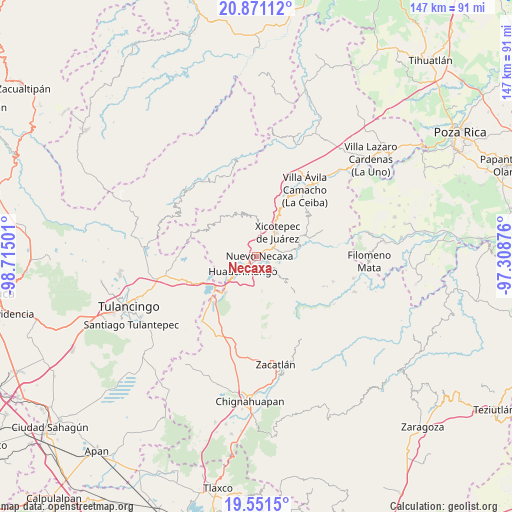
Necaxa GPS coordinates[2]
20° 12' 45.756" North, 98° 0' 42.768" West
| Map corner | latitude | longitude |
|---|---|---|
| Upper-left | 20.87112°, | -98.71501° |
| Center: | 20.21271°, | -98.01188° |
| Lower-right: | 19.5515°, | -97.30876° |
| Map W x H: | 146.7×146.7 km | = 91.2×91.2mi |
| max Lat: | 32.7° ⇑38.4% North |
| Necaxa: | 20.21271° |
| min Lat: | ⇓61.6% South 14.53588° |
| min Long | Necaxa | max Long |
| -117.105° | -98.01188° | -86.73105° |
| W 63.5%⇐ | ⇒36.5% E |
Elevation
Elevation of Necaxa is 1353 m = 4439 ft, and this is 99.3 m = 326 ft above average elevation for this country.
| Max E: |
3497 m = 11473 ft | 51.7% |
| Necaxa | 1353 m 4439 ft | |
| Avg. | 1253.7 m = 4113 ft | |
Min E: |
-1 m = -3 ft | 48.3% |
See also: Mexico elevation on elevation.city.
Geographical zone
Necaxa is located in North Torrid zone (between Equator and Tropic of Cancer). Distance of this Northern Tropic circle is 358.5 km =222.8 mi to North.| Distance of | km | miles | from Necaxa |
|---|---|---|---|
| North Pole | 7759.6 | 4821.6 | to North |
| Arctic Circle | 5153.7 | 3202.4 | to North |
| Tropic Cancer | 358.5 | 222.8 | to North |
| Equator | 2247.4 | 1396.5 | to South |


Nearby cities:
15 places around Necaxa: (largest is in red/bold)
• Cuacuila
5 km =3.1 mi,  204°
204°
• Cuautlita
2 km =1.2 mi,  211°
211°
• Cuaxicala
3.3 km =2.1 mi,  331°
331°
• Duraznotla
6.6 km =4.1 mi,  33°
33°
• Huauchinango
6.2 km =3.9 mi,  226°
226°
• Las Colonias de Hidalgo
4.1 km =2.5 mi,  116°
116°
• Necaxaltépetl
3 km =1.9 mi, 33°
• Nuevo Necaxa
0.6 km =0.4 mi,  114°
114°
• Papatlazolco
4.4 km =2.7 mi,  151°
151°
• Patoltecoya
2.1 km =1.3 mi,  254°
254°
• San Isidro
6.7 km =4.2 mi,  51°
51°
• Tenango de las Flores
2.6 km =1.6 mi, 107°
• Tzahuinco
1.9 km =1.2 mi,  129°
129°
• Xaltepec
5.4 km =3.4 mi,  168°
168°
• Xaltepuxtla
5.9 km =3.7 mi, 134°
Sources, notices
• [Note1] Compared only with cities in Mexico existing in our database
• [Src1] Map data: © OpenStreetMap contributors (CC-BY-SA)
• [Src2] Other city data from geonames.org with taken over terms of usage.
• [Src3] Geographical zone / Annual Mean Temperature by Robert A. Rohde @ Wikipedia
