Patoltecoya geodata
Patoltecoya (Puebla) is a populated place; located in Mexico in America/Mexico_City (GMT-6) time zone. With population of 963 people, there are 9035 cities with bigger population in this country. Compared to other cities in Mexico, 61.5% of cities are located further ↓South; 63.2% of cities are located further ←West and 52.7% of cities have higher elevation than Patoltecoya. Note1


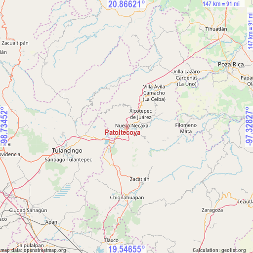
Patoltecoya GPS coordinates[2]
20° 12' 28.008" North, 98° 1' 53.004" West
| Map corner | latitude | longitude |
|---|---|---|
| Upper-left | 20.86621°, | -98.73452° |
| Center: | 20.20778°, | -98.03139° |
| Lower-right: | 19.54655°, | -97.32827° |
| Map W x H: | 146.7×146.7 km | = 91.2×91.2mi |
| max Lat: | 32.7° ⇑38.5% North |
| Patoltecoya: | 20.20778° |
| min Lat: | ⇓61.5% South 14.53588° |
| min Long | Patoltecoya | max Long |
| -117.105° | -98.03139° | -86.73105° |
| W 63.2%⇐ | ⇒36.8% E |
Elevation
Elevation of Patoltecoya is 1304 m = 4278 ft, and this is 50.3 m = 165 ft above average elevation for this country.
| Max E: |
3497 m = 11473 ft | 52.7% |
| Patoltecoya | 1304 m 4278 ft | |
| Avg. | 1253.7 m = 4113 ft | |
Min E: |
-1 m = -3 ft | 47.3% |
See also: Mexico elevation on elevation.city.
Geographical zone
Patoltecoya is located in North Torrid zone (between Equator and Tropic of Cancer). Distance of this Northern Tropic circle is 359 km =223.1 mi to North.| Distance of | km | miles | from Patoltecoya |
|---|---|---|---|
| North Pole | 7760.2 | 4822 | to North |
| Arctic Circle | 5154.3 | 3202.7 | to North |
| Tropic Cancer | 359 | 223.1 | to North |
| Equator | 2246.9 | 1396.2 | to South |


Nearby cities:
15 places around Patoltecoya: (largest is in red/bold)
• Cuacuila
4 km =2.5 mi,  180°
180°
• Cuautlita
1.5 km =0.9 mi,  139°
139°
• Cuaxicala
3.5 km =2.2 mi,  7°
7°
• Huauchinango
4.5 km =2.8 mi,  212°
212°
• Huilacapixtla
5.3 km =3.3 mi,  275°
275°
• Las Colonias de Hidalgo
5.9 km =3.7 mi,  102°
102°
• Necaxa
2.1 km =1.3 mi,  74°
74°
• Necaxaltépetl
4.7 km =2.9 mi,  50°
50°
• Nuevo Necaxa
2.6 km =1.6 mi,  83°
83°
• Ocpaco
6.9 km =4.3 mi, 183°
• Papatlazolco
5.3 km =3.3 mi,  129°
129°
• Tenango de las Flores
4.5 km =2.8 mi,  92°
92°
• Tzahuinco
3.5 km =2.2 mi, 100°
• Xaltepec
5.7 km =3.5 mi,  146°
146°
• Xaltepuxtla
7.2 km =4.5 mi,  120°
120°
Sources, notices
• [Note1] Compared only with cities in Mexico existing in our database
• [Src1] Map data: © OpenStreetMap contributors (CC-BY-SA)
• [Src2] Other city data from geonames.org with taken over terms of usage.
• [Src3] Geographical zone / Annual Mean Temperature by Robert A. Rohde @ Wikipedia
