Patlanoaya geodata
Patlanoaya (Puebla) is a populated place; located in Mexico in America/Mexico_City (GMT-6) time zone. With population of 763 people, there are 11483 cities with bigger population in this country. Compared to other cities in Mexico, 72.6% of cities are located further ↑North; 60.1% of cities are located further ←West and 58.5% of cities have higher elevation than Patlanoaya. Note1


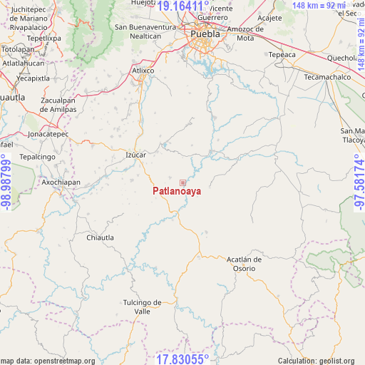
Patlanoaya GPS coordinates[2]
18° 29' 55.068" North, 98° 17' 5.496" West
| Map corner | latitude | longitude |
|---|---|---|
| Upper-left | 19.16411°, | -98.98799° |
| Center: | 18.49863°, | -98.28486° |
| Lower-right: | 17.83055°, | -97.58174° |
| Map W x H: | 148.3×148.3 km | = 92.1×92.1mi |
| max Lat: | 32.7° ⇑72.6% North |
| Patlanoaya: | 18.49863° |
| min Lat: | ⇓27.4% South 14.53588° |
| min Long | Patlanoaya | max Long |
| -117.105° | -98.28486° | -86.73105° |
| W 60.1%⇐ | ⇒39.9% E |
Elevation
Elevation of Patlanoaya is 1082 m = 3550 ft, and this is 171.7 m = 563 ft below average elevation for this country.
| Max E: |
3497 m = 11473 ft | 58.5% |
| Avg. | 1253.7 m = 4113 ft | |
| Patlanoaya | 1082 m = 3550 ft | |
Min E: |
-1 m = -3 ft | 41.5% |
See also: Mexico elevation on elevation.city.
Geographical zone
Patlanoaya is located in North Torrid zone (between Equator and Tropic of Cancer). Distance of this Northern Tropic circle is 549.1 km =341.2 mi to North.| Distance of | km | miles | from Patlanoaya |
|---|---|---|---|
| North Pole | 7950.2 | 4940 | to North |
| Arctic Circle | 5344.3 | 3320.8 | to North |
| Tropic Cancer | 549.1 | 341.2 | to North |
| Equator | 2056.9 | 1278.1 | to South |


Nearby cities:
15 places around Patlanoaya: (largest is in red/bold)
• Ahuatlán
8.8 km =5.5 mi,  19°
19°
• Coatzingo
17.3 km =10.7 mi,  43°
43°
• San Francisco de Asís
7 km =4.3 mi,  175°
175°
• San José las Bocas
18.3 km =11.4 mi,  310°
310°
• San Juan Epatlán
18.5 km =11.5 mi,  330°
330°
• San Juan Raboso
18.2 km =11.3 mi,  296°
296°
• San Miguel las Minas
5.6 km =3.5 mi,  292°
292°
• San Pedro Calantla
15.9 km =9.9 mi, 312°
• San Pedro Cuayuca
10.9 km =6.8 mi,  99°
99°
• Santa Ana Necoxtla
16.4 km =10.2 mi,  320°
320°
• Santa Cruz Tejalpa
17.3 km =10.7 mi,  207°
207°
• Tejaluca
15.8 km =9.8 mi,  13°
13°
• Totoltepec
18.3 km =11.4 mi,  339°
339°
• Xochiltepec
18.1 km =11.2 mi, 339°
• Xuchapa
18.4 km =11.4 mi,  279°
279°
Sources, notices
• [Note1] Compared only with cities in Mexico existing in our database
• [Src1] Map data: © OpenStreetMap contributors (CC-BY-SA)
• [Src2] Other city data from geonames.org with taken over terms of usage.
• [Src3] Geographical zone / Annual Mean Temperature by Robert A. Rohde @ Wikipedia
