Xochiltepec geodata
Xochiltepec (Puebla) is a seat of a second-order administrative division; located in Mexico in America/Mexico_City (GMT-6) time zone. With population of 1,385 people, there are 6250 cities with bigger population in this country. Compared to other cities in Mexico, 70.8% of cities are located further ↑North; 59.3% of cities are located further ←West and 51.9% of cities have higher elevation than Xochiltepec. Note1


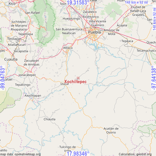
Xochiltepec GPS coordinates[2]
18° 39' 3.42" North, 98° 20' 40.2" West
| Map corner | latitude | longitude |
|---|---|---|
| Upper-left | 19.31583°, | -99.04763° |
| Center: | 18.65095°, | -98.3445° |
| Lower-right: | 17.98346°, | -97.64138° |
| Map W x H: | 148.1×148.1 km | = 92×92mi |
| max Lat: | 32.7° ⇑70.8% North |
| Xochiltepec: | 18.65095° |
| min Lat: | ⇓29.2% South 14.53588° |
| min Long | Xochiltepec | max Long |
| -117.105° | -98.3445° | -86.73105° |
| W 59.3%⇐ | ⇒40.7% E |
Elevation
Elevation of Xochiltepec is 1346 m = 4416 ft, and this is 92.3 m = 303 ft above average elevation for this country.
| Max E: |
3497 m = 11473 ft | 51.9% |
| Xochiltepec | 1346 m 4416 ft | |
| Avg. | 1253.7 m = 4113 ft | |
Min E: |
-1 m = -3 ft | 48.1% |
See also: Mexico elevation on elevation.city.
Geographical zone
Xochiltepec is located in North Torrid zone (between Equator and Tropic of Cancer). Distance of this Northern Tropic circle is 532.1 km =330.6 mi to North.| Distance of | km | miles | from Xochiltepec |
|---|---|---|---|
| North Pole | 7933.3 | 4929.5 | to North |
| Arctic Circle | 5327.4 | 3310.3 | to North |
| Tropic Cancer | 532.1 | 330.6 | to North |
| Equator | 2073.8 | 1288.6 | to South |


Nearby cities:
15 places around Xochiltepec: (largest is in red/bold)
• Ahuatlán
12.7 km =7.9 mi,  133°
133°
• Ayotla
3.6 km =2.2 mi,  305°
305°
• Izúcar de Matamoros
13.5 km =8.4 mi,  245°
245°
• La Galarza
11.8 km =7.3 mi,  279°
279°
• San José las Bocas
9 km =5.6 mi,  236°
236°
• San Juan Epatlán
3.1 km =1.9 mi, 252°
• San Juan Raboso
13.4 km =8.3 mi,  228°
228°
• San Pedro Calantla
8.1 km =5 mi,  221°
221°
• Santa Ana Necoxtla
5.8 km =3.6 mi, 224°
• Santa María Xoyatla
12.5 km =7.8 mi,  337°
337°
• Tejaluca
10 km =6.2 mi,  99°
99°
• Teopantlán
10.9 km =6.8 mi,  51°
51°
• Tepeojuma
13.5 km =8.4 mi, 307°
• Totoltepec
0.3 km =0.2 mi,  303°
303°
• Xoyatla
12.4 km =7.7 mi, 336°
Sources, notices
• [Note1] Compared only with cities in Mexico existing in our database
• [Src1] Map data: © OpenStreetMap contributors (CC-BY-SA)
• [Src2] Other city data from geonames.org with taken over terms of usage.
• [Src3] Geographical zone / Annual Mean Temperature by Robert A. Rohde @ Wikipedia
