Tehuitzingo geodata
Tehuitzingo (Puebla) is a populated place; located in Mexico in America/Mexico_City (GMT-6) time zone. With population of 5,456 people, there are 1705 cities with bigger population in this country. Compared to other cities in Mexico, 74.5% of cities are located further ↑North; 60.2% of cities are located further ←West and 58.6% of cities have higher elevation than Tehuitzingo. Note1


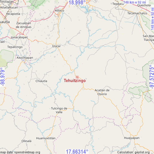
Tehuitzingo GPS coordinates[2]
18° 19' 54.696" North, 98° 16' 33.132" West
| Map corner | latitude | longitude |
|---|---|---|
| Upper-left | 18.998°, | -98.979° |
| Center: | 18.33186°, | -98.27587° |
| Lower-right: | 17.66314°, | -97.57275° |
| Map W x H: | 148.4×148.4 km | = 92.2×92.2mi |
| max Lat: | 32.7° ⇑74.5% North |
| Tehuitzingo: | 18.33186° |
| min Lat: | ⇓25.5% South 14.53588° |
| min Long | Tehuitzingo | max Long |
| -117.105° | -98.27587° | -86.73105° |
| W 60.2%⇐ | ⇒39.8% E |
Elevation
Elevation of Tehuitzingo is 1074 m = 3524 ft, and this is 179.7 m = 590 ft below average elevation for this country.
| Max E: |
3497 m = 11473 ft | 58.6% |
| Avg. | 1253.7 m = 4113 ft | |
| Tehuitzingo | 1074 m = 3524 ft | |
Min E: |
-1 m = -3 ft | 41.4% |
See also: Mexico elevation on elevation.city.
Geographical zone
Tehuitzingo is located in North Torrid zone (between Equator and Tropic of Cancer). Distance of this Northern Tropic circle is 567.6 km =352.7 mi to North.| Distance of | km | miles | from Tehuitzingo |
|---|---|---|---|
| North Pole | 7968.8 | 4951.6 | to North |
| Arctic Circle | 5362.9 | 3332.4 | to North |
| Tropic Cancer | 567.6 | 352.7 | to North |
| Equator | 2038.3 | 1266.5 | to South |


Nearby cities:
15 places around Tehuitzingo: (largest is in red/bold)
• Ahuehuetitla
14.5 km =9 mi,  155°
155°
• Atopoltitlán
7.5 km =4.7 mi,  196°
196°
• Axutla
19.9 km =12.4 mi,  217°
217°
• Chinantla
14.6 km =9.1 mi,  175°
175°
• Hermenegildo Galeana
20.1 km =12.5 mi,  114°
114°
• La Noria Hidalgo
8.8 km =5.5 mi,  99°
99°
• Patlanoaya
18.6 km =11.6 mi,  357°
357°
• Piaxtla
14.9 km =9.3 mi,  171°
171°
• San Bernardo
22.4 km =13.9 mi,  126°
126°
• San Francisco Rancho Nuevo
24.1 km =15 mi, 109°
• San Francisco de Asís
11.6 km =7.2 mi, 357°
• San Miguel las Minas
21.6 km =13.4 mi,  343°
343°
• San Pedro Cuayuca
19.4 km =12.1 mi,  30°
30°
• San Vicente Boquerón
24 km =14.9 mi, 103°
• Santa Cruz Tejalpa
9.4 km =5.8 mi,  289°
289°
Sources, notices
• [Note1] Compared only with cities in Mexico existing in our database
• [Src1] Map data: © OpenStreetMap contributors (CC-BY-SA)
• [Src2] Other city data from geonames.org with taken over terms of usage.
• [Src3] Geographical zone / Annual Mean Temperature by Robert A. Rohde @ Wikipedia
