Axutla geodata
Axutla (Puebla) is a seat of a second-order administrative division; located in Mexico in America/Mexico_City (GMT-6) time zone. With population of 561 people, there are 15205 cities with bigger population in this country. Compared to other cities in Mexico, 76.4% of cities are located further ↑North; 58.8% of cities are located further ←West and 61.8% of cities have higher elevation than Axutla. Note1


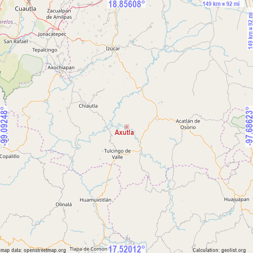
Axutla GPS coordinates[2]
18° 11' 21.768" North, 98° 23' 21.66" West
| Map corner | latitude | longitude |
|---|---|---|
| Upper-left | 18.85608°, | -99.09248° |
| Center: | 18.18938°, | -98.38935° |
| Lower-right: | 17.52012°, | -97.68623° |
| Map W x H: | 148.5×148.5 km | = 92.3×92.3mi |
| max Lat: | 32.7° ⇑76.4% North |
| Axutla: | 18.18938° |
| min Lat: | ⇓23.6% South 14.53588° |
| min Long | Axutla | max Long |
| -117.105° | -98.38935° | -86.73105° |
| W 58.8%⇐ | ⇒41.2% E |
Elevation
Elevation of Axutla is 888 m = 2913 ft, and this is 365.7 m = 1200 ft below average elevation for this country.
| Max E: |
3497 m = 11473 ft | 61.8% |
| Avg. | 1253.7 m = 4113 ft | |
| Axutla | 888 m = 2913 ft | |
Min E: |
-1 m = -3 ft | 38.2% |
See also: Mexico elevation on elevation.city.
Geographical zone
Axutla is located in North Torrid zone (between Equator and Tropic of Cancer). Distance of this Northern Tropic circle is 583.4 km =362.5 mi to North.| Distance of | km | miles | from Axutla |
|---|---|---|---|
| North Pole | 7984.6 | 4961.4 | to North |
| Arctic Circle | 5378.7 | 3342.2 | to North |
| Tropic Cancer | 583.4 | 362.5 | to North |
| Equator | 2022.5 | 1256.7 | to South |


Nearby cities:
15 places around Axutla: (largest is in red/bold)
• Acaxtlahuacán de Albino Zertuche
24.9 km =15.5 mi,  219°
219°
• Ahuehuetitla
18.1 km =11.2 mi,  81°
81°
• Atopoltitlán
13.1 km =8.1 mi,  48°
48°
• Chila de la Sal
13.5 km =8.4 mi,  228°
228°
• Chinantla
13.3 km =8.3 mi, 84°
• Guadalupe Victoria
23.6 km =14.7 mi,  179°
179°
• Ilamacingo
25.7 km =16 mi,  142°
142°
• La Noria Hidalgo
25.2 km =15.7 mi,  55°
55°
• Piaxtla
14.3 km =8.9 mi,  85°
85°
• Progreso
18.8 km =11.7 mi,  153°
153°
• Santa Cruz Tejalpa
19.2 km =11.9 mi,  9°
9°
• Tecomatlán
12 km =7.5 mi, 137°
• Tehuitzingo
19.9 km =12.4 mi,  37°
37°
• Tulcingo de Valle
17.1 km =10.6 mi,  198°
198°
• Xicotlán
20.3 km =12.6 mi, 224°
Sources, notices
• [Note1] Compared only with cities in Mexico existing in our database
• [Src1] Map data: © OpenStreetMap contributors (CC-BY-SA)
• [Src2] Other city data from geonames.org with taken over terms of usage.
• [Src3] Geographical zone / Annual Mean Temperature by Robert A. Rohde @ Wikipedia
